Marine Navigation: Celestial and electronic [Book]
Product Specification
-
Authors: Richard R. HobbsPages: 322Format: hardbackPublication Date: December 1, 1974Key Terms: celestial navigation, Nautical Almanac, celestial horizon, celestial sphere, sky wave, Polaris, Canopus, U.S. Navy, latitude, longitude, fathometer, Loran, celestial equator, Decca, Corr, NAVSAT, Greenwich meridian, interpolation, slave station, Starfinder
-
Universal Product Identifiers
ISBN: 0870213652GTIN: 09780870213656
Related Products
-
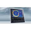
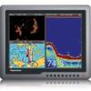
CH270/312 180 kHz Searchlight Sonar System with 10.4 Inch Color LCD Display. Includes 350mm Travel Hoist and Operates at 12VDC
-
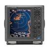
1835 10.4" Color LCD Radar 24" 4KW Dome
-
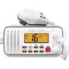
M412 11 Fixed-Mount 25W VHF Marine Radio with Class D DSC (b
-
Mr F55-D Marine Class-D DSC Technology Fixed Mount 25-Watt
-
290 Marine Navigation ROADrule Marine Navigation Aids
-
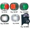
European Style Navigation Lights, Red Side Light, Black Perko
-
30 Amp 25' Cord Set - White - 125V
-
G150 15 Inch Inverted Marine Display #E62248
-
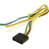
Trailer Wire Male Connector Trailer Connection
-
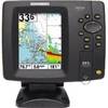
500 Series 597ci Combo - Marine Chartplotter - 4.5" color - 480 x 640
-
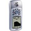
GPSMAP 76S - Marine, hiking GPS receiver - Monochrome - 240 x 180
-
E62186-IN - A50D 5 Combo, Inland Maps, Int GPS