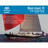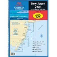
Waterproof Chart Kit - New Jersey Coast 35271
Model: 35271 Brand: Maptech
Waterproof Charts w/ Companion CD WPB0360 360: New Jersey Coast New York Harbor to Cape May, NJ. 24 chart pages. Features GPS waypoints, Lat. /Long. grids, pre-plotted courses, ramps, and 425 marine facilities. 12 x 17, scales 1:1,263,000 to 1:15,000. Product Overview These easy-to-use, compact chart books are ideal for Day-Sailors, Fishing Boats, and Trailer Boats. GPS Ready New features make Waterproof Chartbooks easy to use with your GPS. Most charts include one-minute lat./long. grids to make vessel positioning a breeze, and major navigation aids are identified with named GPS waypoints. Small and Large-Scale Charts Waterproof Chartbooks include small-scale, wide area charts as well as large-scale, detailed charts of harbors and approaches. The Chart Page Index (on the front cover) and "Go-To" page numbers make it simple to quickly find the chart you want. Pre-Plotted Courses Maptech's navigation editors add magnetic courses between major navigation aids with distances in nautical miles. Chartbooks are also designed to help you do the calculations yourself. Each page includes a Compass Rose with annual increase in variation and complete scale information. Waterproof and Tear-Resistant Waterproof Chartbooks have a durable plastic binding and are printed on high-quality, waterproof, tear-resistant paper. Chart images are crisp and easy-to-read. They can handle just about any conditions you'll find on the water - yes, that includes a spilled drink or two! "Paper and Digital Charts Together!" - A Maptech Exclusive It's all here...digital charts and the software tools to use them. And the great thing is the digital charts are the same identical charts with GPS waypoints and course lines - just like in the Chartbooks. Click to Create Routes Chartbook Companion CDs include "Offshore Navigator Lite" navigation software. Click your mouse to put a waypoint on a chart. Click again, and you're creating a route. It's that easy. Distances, bearings and GPS positions are calculated and displayed instantly « less
Product Specification
-
Universal Product Identifiers
Part Number: 35271
Related Products
-
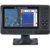
Chartmaster Pro Combo - External U1-CHRT-PRO
-
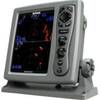
T-940-4 4KW 4.5' Open Array Radar
-
PAPR08; Region 8 Paper Chart Kit
-
4119 Channel Isls/Venture - Santa
-
B16420Cx 1kW 50200khz 20 Deg Tilted Element
-
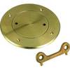
0526003PLB 3" Bronze Deck Plate
-
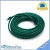
50ft 24AWG Cat6 550mhz UTP Ethernet Bare Copper Network Cable - Green
-
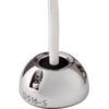
Mini Deck Seal SS Connector .63 Cable .35
-
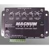
ME-AGS-S - Automatic Gen Start Module, Stand Alone
-
12.5 Beg Generator
-
VHF 200 25W VHF Radio 010-00755-00
-
T70103 e7D 7" Multifunction Display w/Sonar, Internal G