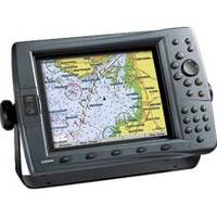
GPSMAP 2210 - Marine GPS receiver
Model: 2210 Brand: Garmin
For boaters looking for value-priced, large-display color chartplotters with limited networking capability and preloaded marine cartography, the GPSMAP 2200 series chartplotters are right on course. The GPSMAP 2210's 10-inch diagonal displays let you see more "big picture" navigation detail with less panning and zooming. Better still, this non-network plotter also comes preloaded with detailed marine cartography utilizing BlueChart g2 technology. The unit accepts up to two optional data cards for loading additional map coverage of inland lakes or BlueChart detail for other regions. « less
Product Specification
-
General
Product Type: GPS receiverRecommended Use: MarineFirst Seen On Google Shopping: February 2006 -
Display
Type: LCD -
Universal Product Identifiers
Part Numbers: 010-00525-00, 2210GTIN: 00753759053031
Related Products
-
RoadMate 2036 - Automotive GPS receiver - 4.3" color - 480 x 272
-
010-00705-00 - GHP 10 Autopilot Corepack (Powerboats)
-
Package(E140W, GPS Antenna, 4KW 24 Inch Digital Radome & Radar Cable )
-
Radar Pole Mount 8' Kit for Raymarine 2KW and 4KW
-
BlueChart g2 Vision - Lake Michigan - Maps
-
010-C0774-20 Bluechart G2 HXEU016RMediterranean Southeast
-
FBRS 2744 Battery Service Include 1098.1 Bat Parts Labor
-
0526004PLB 4" Bronze Deck Plate
-
176 Marine Navigation Ultralight Divider
-
30 Amp 25' Cord Set - Yellow - 125V
-
USB 3.0 Cable | Black | 3ft | Type A to Type A | Male/Male
-
150AY Y Adapter, 2-15 20 Amp Straight Blade to 30 Amp Locking
