4123 La &Amp; Orange County Inshore
Model: 4123 Brand: Fish-n-Map
FISH-N-MAP UNDERWATER TOPOGRAPHY MAPSMade of waterproof, tear resistant plastic. Features include: underwater depth contours, fish locations, latitude and longitude for GPS, multiple freshwater lakes on one map, boat ramps, recreational facilities and much more.
Product Specification
-
Universal Product Identifiers
Part Number: 4123GTIN: 00761428041234
Related Products
-
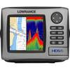
HDS-5 Multifunction Fishfinder/Chartplotter w/o Transdu 34246
-
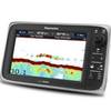
E97 Multifunction 9" Display with Sonar - aus, NZ, S. America, Asia Charts T70045 c44345
-
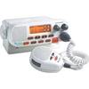
MRF45 VHF Two-way radio
-
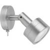
Marine ILIM4040 Hobart LED Reading Chart Marine Light
-
BlueChart g2 - The Netherlands (HEU018R) - Maps
-
Australia South Platinum Marine Charts on SD Card MSD/61P+
-
E12169 S1000 Pilot with Wireless Control
-
30ft 24AWG Cat5e 350MHz UTP Bare Copper Ethernet Network Cable - Blue
-
ATA-100/133, FC 40 Pin (80C) x 3, 30 Awg, 40TP Black Round Cable, 18 Inch
-
10ft Premium 3.5mm Stereo Male to 2rca Male 22AWG Cable 5599
-
DCE/DTE DB60 Crossover Cable - 1ft
-
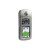
GPSMAP 76CS - Marine, hiking GPS receiver - 2.6" color - 160 x 240