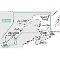
NT+ - St. Lawrence River and Approaches NA-C202
Model: NA-C202 Brand: C-Map
C-MAP has set the standard for electronic charts with five consecutive NMEA awards for "Best Electronic Cartography". The spring 2004 C-MAP NT+ release will include marina detail for over 1,000 US marinas in C-MAPs private collection. Now you will be able to see slip detail as well as the locations for onshore facilities. Finding the right chart plotter for you is easy with 17 manufacturers powered by C-MAP. Just look for the NT+ logo. « less
Product Specification
-
Universal Product Identifiers
Part Number: NA-C202GTIN: 00686074003781
Related Products
-
1734C NavNet vx2 Radar System
-
700 Series - Transducer - included transducer : XNT-9-QB-90-T - quad-beam
-
Max IN-M203 W68 Gulf of Martaban to Jakarta-MAX
-
Max AN-M202 W50 Korea Strait, Okinawa Shima-MAX
-
010-C0924-20 Bluechart G2 HXAW005RThe Gulf & Red Sea Microsd/sd
-
0834007PLB Seacock w/Curved TP 1-1/4in
-
Ethernet Over Power Adapter (Pair) - 200Mbps
-
12ft 22AWG 5-rca Component Video/audio Coaxial Cable (RG-59/U) - Black
-
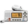
M424 Fixed Mount DSC VHF Marine Radio
-
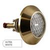
3010 Thru Hull Underwater Light - Super White
-
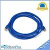
10ft 24AWG Cat6a 500mhz Stp Ethernet Bare Copper Network Cable - Blue
-
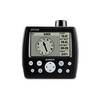
GPS 152H - Marine GPS receiver - 4" monochrome - 100 x 160