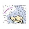
NOAA Dixon Entrance-Cape St. Elias
Dept. of Commerce - 16016; NOAA nautical charts Encompasses the southern part of Southeast Alaska Note: Ensure that your charts are kept current to reflect changes to that area
Product Specification
-
Universal Product Identifiers
Part Number: 16016
Related Products
-
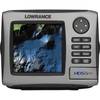
HDS-5m Nautic Insight Chartplotter - Coastal Data 34262
-
NA-M033 C-Card Format - Atlantic Coast Gulf Caribbean
-
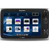
E125 Multifuntion Display - No Preloaded Charts Map
-
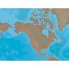
NOAA Int Footl/N Pac Ocean/Bering Sea-South
-
Norwood's Epitomie: Or the Application of the Doctrine of Triangles in Certaine Problemes, to the Use of the Plaine Sea-Chart, and Mercators-Chart Being the Two Principall and Most Usefull Kinds of Sayling. (1645) [Book]
-
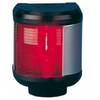
40300-7 S40 Port Navigation Light 12v/25w
-
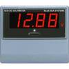
8235 Meter Digital DC Voltage
-
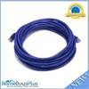
20ft 24AWG Cat6 550mhz UTP Ethernet Bare Copper Network Cable - Purple
-
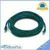
20ft 24AWG Cat6 550mhz UTP Ethernet Bare Copper Network Cable - Green
-
7ft 24AWG Cat5e 350MHz UTP Bare Copper Ethernet Network Cable - Red
-
2668 25ft Optical Toslink 5.0mm OD Audio Cable
-
18-8803-2 Premium Marine Spark Plug Wire Leads