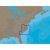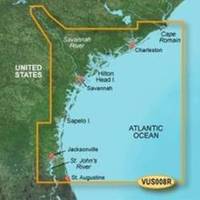
BlueChart g2 Vision - Charleston to Jacksonville - Maps
Model: Brand: Garmin
BlueChart g2 Vision offers the same rich detailed charting of BlueChart g2 to help you get the most out of your unit. In addition, g2 Vision features a growing database of high-resolution satellite imagery, above and below the water 3D perspective, auto guidance technology, aerial photographs for real world reference and coastal roads with points of interest. This product features Cape Romain through St. Augustine including Charleston, Savannah and Jacksonville with the St. John's River covered to the Clay County line. « less
Product Specification
-
General
Product Type: MapsDistribution Media: SD Memory CardFirst Seen On Google Shopping: May 2007 -
Compatibility Information
Designed For: Garmin GPSMAP 4008, 4012, 420, 4208, 420s, 4212, 430, 430s, 430sx, 430x, 440, 440s, 440sx, 440x, 450, 5008, 5012, 520, 5208, 520s, 5212, 525, 525s, 530, 530s, 535, 535s, 540, 540s, 545, 545s, 550, 550s, 555, 555s -
Universal Product Identifiers
Part Numbers: 010-C0709-00, Charleston to JacksonvilleGTIN: 00753759068899
Related Products
-
Package(c127 with USA Coastal Chart, 4KW 18 Inch Digital Radome & Radar Cable)
-
NA-C310 C-Card Format - Cape May - Winyah Bay
-
Inc MSD/PREM-N6 Map, HotMaps Premium North
-
Elements of Navigation, Chart, Lead, & Log Deviation & Compass Compensation, Piloting, Dead Reckoning, Nautical Tables [Book]
-
Navpilot700ob Autopilot Outboard Requires Pump
-
3ft 32AWG Mini DisplayPort Male to Female Extension Cable - White
-
Mountable Head Cable Tie 8 Inch 40lbs, 100pcs/Pack - Black
-
19811 PL259 with Adapter
-
210140 #6 Blue Vinyl Butt Connector (25)
-
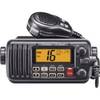
M412 12 Fixed-Mount 25W VHF Marine Radio with Class D DSC (W
-
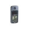
GPSMAP 76 - Marine, hiking GPS receiver - Monochrome - 240 x 180
-
RoadMate RV 9145-LM - Automotive GPS receiver - 7" color - 800 x 480 - widescreen