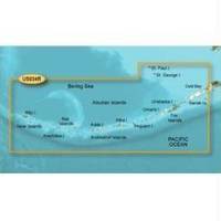
BlueChart g2 Vision - Aleutian Islands - Maps
Model: Brand: Garmin
BlueChart g2 Vision offers the same rich detailed charting of BlueChart g2 to help you get the most out of your unit. In addition, g2 Vision features a growing database of high-resolution satellite imagery, above and below the water 3D perspective, auto guidance technology, aerial photographs for real world reference and coastal roads with points of interest. This product features coverage of the Aleutian Islands from Attu Island to Cold Bay, including Adak Station and Unalaska. Also covers the Pribilof Islands, including St. Paul Island and St. George Island. « less
Product Specification
-
General
Product Type: MapsDistribution Media: SD Memory CardFirst Seen On Google Shopping: June 2007 -
Compatibility Information
Designed For: Garmin GPSMAP 4008, 4012, 420, 4208, 420s, 4212, 430, 430s, 430sx, 430x, 440, 440s, 440sx, 440x, 450, 5008, 5012, 520, 5208, 520s, 5212, 525, 525s, 530, 530s, 535, 535s, 540, 540s, 545, 545s, 550, 550s, 555, 555s -
Universal Product Identifiers
Part Numbers: 010-C0735-00, Aleutian Islands
Related Products
-
Marine Pollution Including Ocean Acidification, Eutrophication, Marine Debris, Mercury in Fish, and Active Sonar [Book]
-
AS-RSL Matrix to Smartcast Sonar Link wasrsl
-
CFHMPTE6 HotMaps Platinum Multi-Dimensional 3D Lake Maps
-
MSD/673P+ Platinum Plus Maine on SD/Micro SD
-
Western U.S. Fishing Maps Sea of Cortez North Chart
-
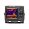
HDS 5x Gen2 - Fishfinder
-
14ft 24AWG Cat5e 350MHz UTP Bare Copper Ethernet Network Cable - Blue
-
Serial cable - (DB-9) - F - 25 ft - PC
-
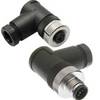
FA-CM-90 - Field CONNECTOR, Male Micro/Mid, 90?
-
Marine Products washer, Drain Plug 9-60202
-
1ft 24AWG Cat5e 350MHz UTP Bare Copper Ethernet Network Cable - Green
-
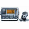
M504 Grey VHF Radio