Western U.S. Fishing Maps Sea of Cortez North Chart
Model: Brand: Fish-n-Map
FISH-N-MAP UNDERWATER TOPOGRAPHY MAPSMade of waterproof, tear resistant plastic. Features include: underwater depth contours, fish locations, latitude and longitude for GPS, multiple freshwater lakes on one map, boat ramps, recreational facilities and much more.
Product Specification
-
Universal Product Identifiers
Part Numbers: 317166, 7123GTIN: 00761428071231
Related Products
-
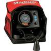
VX-1P 3-Color Sonar Flasher System
-
JMA-5110 Radar 72NM with 10KW 6 Foot Open Array & 10 Inch Color LCD Display
-
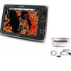
Package(e125 with USA Coastal Chart, 4KW 18 Inch Digital Radome & Radar Cable)
-
Max AN-M203 W51 Yellow Sea to Malaya-MAX
-
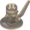
1-1 2 in. Seacock Ball Valve Bronze Made in The USA
-
FBRS 2775 Battery Serive Includes 1096 Batt Parts Labor
-
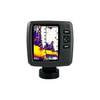
Fishfinder echo 550c - Fishfinder - included transducer - dual-beam
-
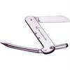
1550 Knife Rigging Standard S/S
-
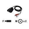
IP35 - Video / audio cable - Female Mini-phone stereo 3.5 mm to M RCA
-
10ft Premium Optical Toslink Cable w/ Metal Fancy Connector
-
6ft 32AWG Mini DisplayPort to DVI Cable - White
-
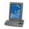
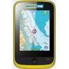
Memory-Map Adventurer 3500 GPS - Marine -Yellow/Black