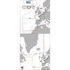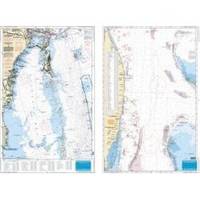
Waterproof Charts 123F Coastal Miami Trolling Chart - FISH/DIVE
Model: 123F Brand:
Pierce south to Key Largo and offshore to the West Bahamas, this chart is derived from 6 different Bathymetric charts which show detailed bottom contour thru the deepest water. Highlighted are popular trolling areas with their local names, which provide the structure for the best deep water, fishing. Over 100 GPS coordinates provide targets for trolling fishermen. The reverse side is coverage from North Miami to Elliot Key and has listings for 85 popular wrecks and reefs, many with GPS/Loran Waypoints. A total of 215 numbers!! 25 x 38 « less
Product Specification
-
Universal Product Identifiers
Part Number: 123F
Related Products
-
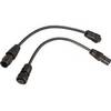
Motor/Sonar Connector Plug
-
XN13A/6 - 6 Foot Open Array Antenna
-
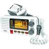
UM415 Oceanus D Marine Radio (White)
-
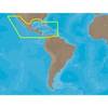
30131 Max - Central America and The Caribbean - C-Card
-
T70040 E95 Multifunction Display w/US Coastal Charts
-
Max EW-M225 W15 France Inland-MAX
-
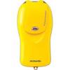
McMurdo Fastfind Max G PLB with Built in GPS XXXXXXXX
-
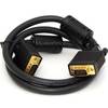
3ft SVGA Super VGA M/M Monitor Cable w/ Ferrites (Gold Plated)
-
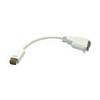
VGA cable Apple mini-DVI - male - 15 pin HD D-Sub (HD-15) - female
-
30ft 24AWG Cat6 550mhz UTP Ethernet Bare Copper Network 5017
-
Th-1202-B Thru Hull 1-1/8" White 1-1/4" Hull
-
8167 Amber LED Indicator Light - 230VAC (EU)