30131 Max - Central America and The Caribbean - C-Card
Model: 30131 Brand: C-Map
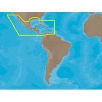
Coverage of the Pacific coast starts at Point Conception, CA and runs down to Bahia Cupica, Colombia. Coverage of the United States starts in Cumberland Sound, GA and runs down around Florida and over to Brownsville, TX. Bahamas, Turks and Caicos and all islands of the Caribbean are included. South American coverage includes the northern coasts of Colombia and Venezuela over to Rio Orinoco, including Trinidad and Tobago. Caribbean coverage includes charts from Explorer Chartbooks and Wavey Line Publising. Specifications:Port Plans: YesAerial Photos: Yes3-D View: Yes « less
Product Specification
-
Universal Product Identifiers
Part Numbers: 30131, CMANAM027CCARD, CMANAM027SD, NA-M027, NA-M027-C, NA-M027C-CARDGTIN: 000000165841, 00686074002814
Related Products
-
JMA-5106 Radar 72NM with 6KW with 4 Foot Open Array & 10 Inch Color LCD Display
-
Marine Lighting, LED, Bulkhead Mount, Ocean Chart Lamp, 10 - 30V DC, Medium, Stainless Steel Finish, Warm
-
010-C0877-20 Bluechart G2 HXAE002RYellow Sea Microsd/sd Adaptor
-
UM415 VHF Fixed Radio 38460
-
Marine Navigation Workbook: Piloting and Celestial and Electronic Navigation [Book]
-
Cat6a Ethernet Cable | 2ft | Yellow | Network | 10 Gigabit
-
6ft 32AWG Mini DisplayPort Cable - White
-
Butt CONNECTOR, Single CRIMP, Nylon Insulated Red, 22-18, 100 Pack
-
Marine Products Plug, Lower Unit Drain 9-72655
-
Ltb Top - Attwood LED 7800 Series Light with 7' Wire LTBA-7800
-
000-10143-001 - Sonichub Marine Audio Server for NSX
-
AIS Dual Channel Receiver & GPS SR162G