Sea Charts of the British Isles: A Voyage of Discovery Around Britain & Ireland's Coastline [Book]
Sea Charts of the British Isles takes the reader on a voyage through the seaports, fishing and commercial harbors, naval bases and dockyards, and sea-side havens that have always supported local life in Britain and contributed to the Isles’ defense. This beautiful collection of charts contains a wealth of information about Britain’s maritime history, as well as the history of charting and surveying. The great names in British chart-making are all included, from Captain Greenvile Collins and Professor Murdoch Mackenzie to Graeme Spence and William Bligh. « less
Product Specification
-
Authors: John Blake, Lie, John Blake (Lieutenant Commander.)Pages: 128Format: hardbackPublication Date: November 19, 2005Key Terms: British Crown Copyright, Trinity House, Royal Navy, British Library, Scotland, British Isles, Admiralty, River Tyne, portolan charts, compass rose, Portland Bill, Pembrokeshire, South Ronaldsay, Isle of Wight, Lowestoft, River Thames, King's Lynn, Pentland Firth, Firth of Clyde, English Channel
-
Universal Product Identifiers
ISBN: 1844860248GTIN: 09781844860241
Related Products
-
AP2804VRF Autopilot AP28,AC42,RC42,RPU160
-
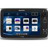
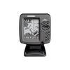
T70053 E127 Multifunction Display w/Sonar - European Charts
-
NAM022C C-Card US East COAST/BAHAMAS
-
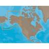
BlueChart g2 Vision - St. Lawrence Seaway - Maps
-
3550G7 LED Navigation Light Green
-
LED Bicolor Light White 12V
-
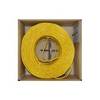
Bulk cable - CAT 5e - Unshielded twisted pair (UTP) 1000 ft - Yellow
-
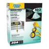
Power Zone ORMAD30Y Marine Y Adptr 30A Plg 30A CON
-
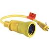
Wiring Device-Kellems Hbl61cm54 Marine Adapter 3d968
-
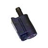
18 8091 Fuel Connector
-
300 Series 365i Combo - Marine Chartplotter - 4" monochrome - 240 x 320
-
MPC-122X-K Marine PC