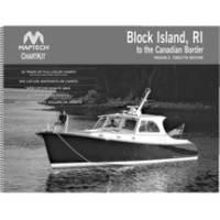
Papr02 Region 2 Paper Chart Kit
Model: Papr02 Brand: Maptech
ChartKits are full-color reproductions of U.S. government and private charts spiral bound into popular cruising regions with aerial photos, pre-plotted courses and more. The convenient-sized books are large enough to allow for manual plotting, yet small enough to sit on your nav-station or lap. Waterproof covers are available. « less
Product Specification
-
Universal Product Identifiers
Part Number: PAPR02
Related Products
-
Radar 4010 Package with GMR18 4KW Radome
-
kv8715 Floating VHF Marine Radio
-
BlueChart g2 Vision - Lake Erie - Lake St. Clair - Maps
-
Marine World Chart of Nicolo de Canerio Januensis [Book]
-
E12206 Smartpilot X-5 Sportpilot
-
Marinenav Leviathan Marine Navigation PC Computer LEV-017R-AMD
-
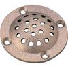
39161 Round Bronze Strainer, for Thru-Hull Size 1"
-
Marine Navigation and Safety of Sea Transportation [Book]
-
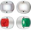
170 Series LED Navigation Lights White Stern, 12V
-
Axxess - AX-FMUSBEXTCB - Male to Female 3.5mm Cable
-
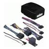
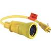
Wiring Device-Kellems Hbl61cm54 Marine Adapter 3d968
-
03348810 FITTING-FUEL Suzuki 3/8in to 75HP