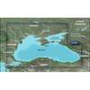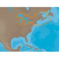
NA-M026 C-Card Format Great Lakes and The Maritimes
Model: NA-M026 Brand: C-Map
NA-M026 => Great Lakes, Northeast Coast and ApproachesCoverage of the Great Lakes, St. Lawrence River and Northeast United States. Coverage of the Great Lakes also includes Fox River and Lake Winnebago, Lake St. Clair, Rideau Canal, Ottawa River and the Trent-Severn Waterway. Includes all coastal charts for New Brunswick and Nova Scotia in Canada and Maine, New Hampshire, Massachusetts, Connecticut and New York in the U.S. Also included is coverage of the Hudson River and Lake Champlain as well as the Erie Barge Canal. Specifications:Port Plans: YesAerial Photos: Yes3-D View: Yes « less
Product Specification
-
Universal Product Identifiers
Part Numbers: 30127, NA-M026, NA-M026C-CARDGTIN: 000000165840, 00686074002791
Related Products
-
E Series: E80/E120 Radar [DVD]
-
PCPLANNER2 PC Planner - NT+/MAX 2MB
-
010-C1064-20 G2 HXRU002R Black Sea & Azov Bluechart SD
-
MT-403FFSVC Hydrostatic Release for MT-403FF & MT-403FG
-
32804 4" Tachometer, 6K, Gas Inboard & I/O
-
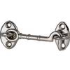
3in Plain Bronze Door Hook
-
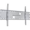
Low Profile Wall Mount Bracket for LCD LED Plasma (Max 165Lbs, 30~63inch) - Silver (No Logo)
-
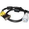
010-10548-00 A/V Cable
-
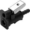
8075 1/4 Mc/Ma/Ya Fuel Connector
-
Marine Products washer, Drain Plug 9-60202
-
Goal Zero - Yeti 1250 1500w/1200w Portable Solar Generator 31901
-
lian I2 System Dish Network Allinone Package WMultiSatellite in