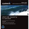
NA-M024 SD Card Format US West Coast and Haw
Model: NA-M024 Brand: C-Map
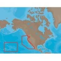
NA-M024 => USA West Coast and HawaiiCoverage of the Pacific Coast of the United States, including all of the coasts of California, Oregon and Washington. Coverage of Baja California and Mexico down to Puerto Vallarta. Detail of the Columbia River, Sacramento River, Willamette River. Snake River and San Joaquin Rivers are also included. Full coverage of Puget Sound and the San Juan Islands up to Point Roberts is also included. Additional coverage of the Hawaiian Islands out to Midway and Johnston Atoll is also included. « less
Product Specification
-
Universal Product Identifiers
Part Numbers: 30147, CMANAM024SD, M-NA-M024, NA-M024-SD, NA-M024SDCARDGTIN: 000000165847, 00686074002746
Related Products
-
AP50 Autopilot System Pack 1 with AP50, J50 (12 Amps), Rudder Feedback RF300 & RC25 Compass
-
SP-70MS Autopilot for Cable Steer Straight Helms st70ms
-
Commander P2 Mono Display, SSRC1 Rate Gyro Compass & Linear Feedback 10110032
-
010-10800-72 Bluechart G2 Map Update
-
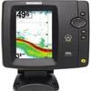
500 Series 586c - Fishfinder - included transducer : XNT-9-20-T - dual-beam
-
Articles on Hydrography, Including: International Hydrographic Organization, Limnology, Hydrographic Survey, Nautical Chart, Hydrographic Office, Bathymetric Chart, Territorial Waters, Canadian Hydrographic Service, Exclusive Economic Zone [Book]
-
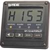
SP110 System w/ rfb & Remote Mech Drive - Sail 8.5"
-
Children's Life Jacket PFD 2
-
PLB-CE3 Ceiling Bracket for 30inch Above TV (To Be Used with PID 2852, 3003, or 3004)
-
QCM-CG1-QCF-01 - Nylon to Metal Connector Cable
-
CP-12L Cigarette Light Adapter for M3A/M2A c10195
-
MPI 480-6000 6 in. Insulated Air Conditioner Duct