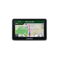
n�vi 2350 - Automotive GPS receiver - 4.3" color - 480 x 272 - widescreen
Model: 2350 Brand: Garmin
nüvi 2350 includes nüRoute technology with trafficTrends historical traffic and myTrends predictive routing. With trafficTrends, your nüvi 2350 automatically learns daytime trends for traffic flow to improve your routes and better predict your estimated time of arrival based on time of day and day of week. With myTrends, when you save your regular destinations in your "favorites" your nüvi 2350 will, over time, begin to figure out where you're going even without your telling it! So whether you're driving to and from work or a regularly scheduled weekly event, your nüvi 2350 will help you get there on time. No subscription or additional cost required. No more guessing which lane you need to be in to make an upcoming turn. Lane assist with junction view guides you to the correct lane for an approaching turn or exit, making unfamiliar intersections and exits easy to navigate. It realistically displays road signs and junctions on your route along with arrows that indicate the proper lane for navigation. Navigation is just the beginning. The 2350 includes many travel tools, including JPEG picture viewer, world travel clock with time zones, currency converter, measurement converter, calculator and more. With photo navigation, you can download pictures from Garmin Connect photos and navigate to them. It's also compatible with lifetime traffic alerts. With its "where am I?" emergency locator, you always know your location. Simply tap the screen to get your exact latitude and longitude coordinates, the nearest address and intersection, and the closest hospitals, police stations and fuel stations. The 2350 features Garmin Lock, an anti-theft feature. « less
Product Specification
-
General
Product Type: GPS receiverRecommended Use: AutomotivePreloaded Maps: North America, Canada, USA, MexicoCard Reader: microSDInterface: USBFunctions & Services: Distance, time/date, Lane AssistantVoice: Navigation instructions, street name announcementIncluded Software: MapSource City Navigator NTCompatible Software: Garmin CityXplorerAntenna: Built-inFeatures: ecoRoute, built-in speaker, calculator, clock, speed limit warning, 2D / 3D map perspective, Garmin Lock, custom POIs, downloadable POIs, preinstalled POIs, currency converter, Garmin Garage, Garmin Locate, nüRoute Technology with trafficTrends, nüRoute Technology with myTrends, photo navigationFirst Seen On Google Shopping: September 2010 -
Display
Type: TFT - color - touch screenDiagonal Size: 4.3" - widescreenWidth: 3.8 inHeight: 2.2 inResolution: 480 x 272Display Illumination: Yes -
Navigation
Waypoints: 1000Routes: 100Trip Computer: Avoid highways, trip timer, quickest route, avoid toll roads, fast/short route, street address search -
Media Player
Supported Image Formats: JPG -
Connections
Interfaces: USB -
Battery
Type: Lithium ionRun Time (Up To): 3 hours -
Miscellaneous
Included Accessories: Dashboard disc, suction cup mount -
Dimensions & Weight
Width: 4.8 inDepth: 0.6 inHeight: 3 inWeight: 5.7 oz -
Universal Product Identifiers
Part Numbers: 010-00902-12, 2350GTIN: 00753759104696, 00753759104719
Related Products
-
p70R & X-10 Corepack & Type 1 Pumpset Autopilot Package for Hydraulic Steered Powerboats T70079 c44130
-
NAVPILOT 711 Autopilot for Inboard without Pumpset
-
T70027 C97 Multifunction Display w/Sonar - US Inland Charts
-
EW-C209 C-Card Format - Irish Sea
-
Colormax 15 Color LCD Chartplotter with WAAS GPS
-
Marine Navigation Workbook: Piloting and Celestial and Electronic Navigation [Book]
-
PH50 50 Foot Phone Cable Set (Yellow)
-
Serial extension cable - (DB-9) - M - (DB-9) - F - 50 ft - PC
-
010-11324-00 - Gra 10 Rudder Angle Adpt
-
Lumishore Thru Hull Flush Fit 18 Watt Blue Underwater Light
-
Whisper 30' Guyed Tower Kit (Whi100/Whi200) (does Not Include Pipe & Anchors)
-
VOYAGER VHF Two-way radio
