MapSource BlueChart - Adriatic Sea, South Coast - Maps
Model: Brand: Garmin
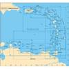
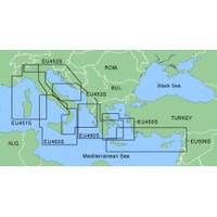
MapSource BlueChart is Garmin's exclusive marine cartography and was developed to provide you with mapping flexibility and options you've never had before. This line of cartography products is designed to provide interactive viewing of detailed nautical chart data, thereby providing navigators with innovative object-oriented cartography. These detailed electronic nautical charts look just like paper charts when displayed on your Garmin chartplotter. Features include shading between depth contours, spot soundings, navaids, port plans, wrecks, obstructions, inter-tidal zones, and more. BlueChart offers much larger coverage areas for half the price. MapSource BlueChart Adriatic Sea, South Coast provides detailed coverage of Italian coast from Porto Civitanova to extend south to Siracusa, Sicilia. From Split, Croatia to Killini, Greece. « less
Product Specification
-
General
Product Type: MapsDistribution Media: microSD Memory CardFirst Seen On Google Shopping: January 2006 -
Compatibility Information
Designed For: Garmin eTrex Legend Cx, Vista Cx Garmin GPSMAP 60CSx, 60Cx, 76CSx, 76Cx -
Universal Product Identifiers
Part Numbers: 010-C0440-00, Adriatic Sea, South Coast
Related Products
-
37593 Escort Sonar Module with Transom Mount, Keypad, Vide
-
A29 Imray Dominica Marine Nautical Chart
-
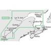
NT+ - St. Lawrence River and Approaches NA-C202
-
XGPS150 - Marine, hiking, automotive, cycle, golf, running GPS receiver
-
LED Stern Transom Mount Black ASL-335027
-
Zeus Sailing Navigation System - 8 in Display 000-10239-001 c43561
-
Green Six Inch Category 5 Enhanced Cat 5e Ethernet Network Cable .5
-
Electronics PC-27BL Power cable - PC
-
3ft Toslink to Mini M/M 5.0mm OD Molded Cable 1556
-
Circle Cable Clips with Steel Nail, 10mm, 100pcs/Pack
-
25' Network Cable for Scp Remote Panel 809-0940
-
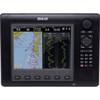
E62188-IN A57D GPS Chartplotter / Fishfinder