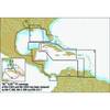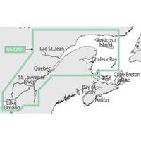
NT+ - St. Lawrence River and Approaches NA-C202
Model: NA-C202 Brand: C-Map
C-MAP has set the standard for electronic charts with five consecutive NMEA awards for "Best Electronic Cartography". The spring 2004 C-MAP NT+ release will include marina detail for over 1,000 US marinas in C-MAPs private collection. Now you will be able to see slip detail as well as the locations for onshore facilities. Finding the right chart plotter for you is easy with 17 manufacturers powered by C-MAP. Just look for the NT+ logo. « less
Product Specification
-
Universal Product Identifiers
Part Number: NA-C202GTIN: 00686074003781
Related Products
-
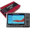
U1-200D-000 SE-200 BB Sonar w/7" Display & Cable No Du
-
Package(C120W, RA1048D 4KW 48 Inch HD Digital Open Array Radar & 15m Radar Cable)
-
Cuba, Jamaica & The Cayman Islands: NT+ Wide Coverage by C-Map
-
Cat6a Ethernet Cable | 3ft | Gray | Network | 10 Gigabit
-
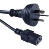
Cable Showcase Austrailian Power Cord UL/CSA, 6 ft
-
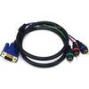
3ft VGA to 3 RCA Component Video Cable (HD15 - 3-rca)
-
10ft USB 2.0 A Male to B Male 28/24AWG Cable (Gold Plated)
-
PDRT-WBL Trolling Mnt w/Remote Temp Blue Connector
-
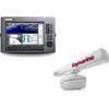
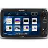
E127 12" Display w/ Sounder and US Coastal Charts
-
18 8076 Fuel Connector for Mercury/Mariner Outboard Motors
-
Whisper 65' Guyed Tower Kit (Whi100/Whi200) (does Not Include Pipe & Anchors)
-
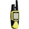
RINO 110 - Hiking GPS receiver / two-way radio - Monochrome - 160 x 160