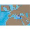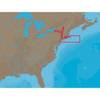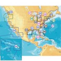
Inc MSD/652P Map, Lake Huron
Model: 652P Brand: Navionics
Navionics 652P+ Lake Huron Platinum+ Multi-Dimensional Charts, with the most advanced technology and best imaging available, provide high-resolution photo/chart overlay, full-view XGA panoramic pictures, improved 3D view, complete geo-referenced coast pilots. Compatibility Guide
Product Specification
-
Universal Product Identifiers
Part Numbers: 11093838, 37651, 652P+, DEF-257881MSD652, MSD-652P-, MSD652P+, SD652PGTIN: '82124565259, 00821245652591
Related Products
-
010-11204-00 Autopilot Isolation Hose Kit
-
010-11417-00 - Heading Sensor (fluxgate Compass)
-
EM-C104 Furuno FP Format - Aegean Sea
-
FR8252 Color 12.1 Inch LCD 25 KW 96Nm Radar with 4' Open Array
-
NA-C302 C-Card Format Cape Cod Long Is & Hudson R
-
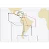
Puerto Bolivar to Rio de Janeiro: NT+ Wide Coverage by C-Map
-
Max EN-M326 W9 Finland Lakes-MAX
-
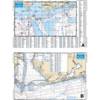
Mobile Bay to Pensacola Offshore Fishing - Waterproof Charts
-
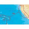
Platinum Plus US West Coast CF/912P+
-
Prod 1.5oz Refill Air Horn 46201
-
Innovative Lighting LED Deck Mount Navigation Light - Stainless Steel
-
LS4100/TM