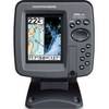
GPSMAP 720 GPS Chartplotter with Internal GPS Antenna 010-00835-00
Model: 010-00835-00 Brand: Garmin
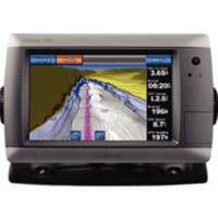
These stand-alone touchscreen chartplotters feature a brilliant 7" color display and includes an internal high-sensitivity GPS receiver for superior satellite tracking and quicker acquisition times. The intuitive touchscreen interface makes operation simple and the widescreen display is waterproof and built to last. With a built-in radar port it is easy to add one of the GMR marine radar systems. Addition of the GXM 51 antenna enables graphical weather data for North America & XM satellite radio. Other features include AIS support DSC position display audible alarms tide tables sun & moon informationa NMEA 0183 & 2000 interface and more. 3000 Waypoints 100 routes 20000 points 50 saved tracks. Standard models are GPS/Chartplotters and do not include sonar capability. S models include a powerful dual frequency 200/50kHz sonar transceiver to help you define fish and underwater structures as deep as 2000' when used with a 1kW transducer. Transducers sold separately. 720/720s include a worldwide basemap. 740/740s include the basemap plus U.S. Coastal maps including Alaska & Hawaii as well as detailed Bahamas charts. « less
Product Specification
-
Universal Product Identifiers
Part Number: 100083500
Related Products
-
386ci Di Down Imaging GPS Fishfinder 409050-1 c46182
-
010-10800-72 Bluechart G2 Map Update
-
2827 Multi Channel GMDSS
-
T70046 E95 Multifunction Display w/US Inland Charts
-
Description of a New Improved Chart of the Islands of Shetland to Which Are Annexed Three Copper Plates and a Special Chart of Valey-Sound, Published from the Royal Danish Marine Archives for Draughts and Charts by P. de Lowenorn, 1787. [Book]
-
3204 Lake Havasu
-
Solara Marine Radio
-
2777.91 FBRS 2777 Battery Replacement Service
-
611 Marine Navigation Compass Nickel 7-inch
-
25ft 22AWG CL2 High Speed HDMI Cable - Black
-
6025 6inch VGA to 3 RCA Component Video Cable (HD15 - 3-rca)
-
Air Breeze 1-ARBM-15-48 Marine Wind Generator 48VDC