3204 Lake Havasu
Model: 3204 Brand: Fish-n-Map
FISH-N-MAP UNDERWATER TOPOGRAPHY MAPSMade of waterproof, tear resistant plastic. Features include: underwater depth contours, fish locations, latitude and longitude for GPS, multiple freshwater lakes on one map, boat ramps, recreational facilities and much more.
Product Specification
-
Universal Product Identifiers
Part Numbers: 234560, 3204GTIN: 00761428032041
Related Products
-
AP5009 Autopilot with AP50, J50, Rudder Feedback RF300, HLD350
-
AP35-6 Autopilot with AP35, J300X, Rudder Feedback RF300, RPU-160 Drive Unit (for Hydraulic Steering) sap35-6
-
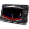
E127 Multifunction Display with Sonar - European Charts T70053 c44356
-
Fishing Hot Spots E112 Pro USA Chart f/Lowrance
-
010-C0878-10 Bluechart G2 HAE003RTaiwan Data Card
-
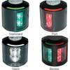
Series 43 Black LED Navigation Light Port
-
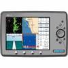
Marine EC11 GPS-Chartplotter/Fish Finder with External Antenna, C-Map Max Card & 10.4" Color Display; NMEA Network Compatible - SI-TEX
-
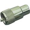
329900-1 UHF Connector Male F/8U Cable
-
SeatalkHS Network Cable
-
A62245 Sea Talk High Speed Dual End Weatherproof
-
Cat6a Ethernet Cable | 75ft | White | Network | 10 Gigabit
-
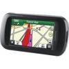
Montana 650t Handheld GPS 41813