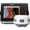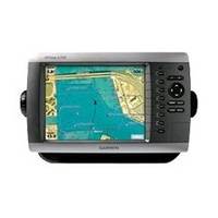
GPSMAP 4208 - Marine GPS receiver - 8.4" color - 640 x 480
Model: 4208 Brand: Garmin
This preloaded, offshore chartplotter combines the power of networking with brilliant color and slim-line design. The GPSMAP 4208 has preloaded BlueChart g2 maps of the U.S. coast and displays them on an 8.4" VGA display with video-quality resolution. By connecting to the Garmin Marine Network, you can add sonar, radar and weather. The 4208 features highly-detailed BlueChart g2 marine cartography of the coastal United States, including Alaska, Hawaii and the Bahamas. This data provides detailed coastlines, shaded depth contours, navaids, port plans, wrecks, restricted areas and tide and current information. For other areas, the 4208 has a worldwide basemap with high-quality satellite images in place of more traditional maps. With the SD card slot, you can add additional maps without having to connect to a computer. The 4208's high-speed processor draws maps quickly, and its simple intuitive interface makes navigating easy. To keep tabs on your engine room or other area of your boat, you can also connect a live video feed with the 4208's video input and output options. The 4208 connects easily to the high-speed Garmin Marine Network, so you can interface with additional MFDs and add remote sensors. Once connected, you can share information between the 4208 and other chartplotters on your boat. You can also add high-powered radar, sonar and XM satellite weather and radio to your system. This product is bundled with GPS 17 with pole mount adapter. « less
Product Specification
-
General
Product Type: GPS receiverRecommended Use: MarinePreloaded Maps: USACard Reader: SD Memory CardInterface: NMEA 0183, NMEA 2000Included Software: Garmin Worldwide Marine BasemapCompatible Software: BlueChart g2 VisionSBAS: WAASAntenna: ExternalFeatures: Optional external GPS antenna connection, alarm, 2D / 3D map perspectiveFirst Seen On Google Shopping: February 2007 -
Display
Type: TFT - colorDiagonal Size: 8.4"Resolution: 640 x 480 -
Navigation
Waypoints: 1500Tracks: 20Tracklog Points: 10000Routes: 20Trip Computer: Sunrise/sunset times, sun/moon positions -
Connections
Interfaces: Garmin Marine Network -
Miscellaneous
Protection: WaterproofWaterproof Standard: IPX7Included Accessories: Protective cover, PC cable, mounting bracket, power cable -
Dimensions & Weight
Width: 11.2 inDepth: 4.6 inHeight: 7 inWeight: 5.1 lbs -
Universal Product Identifiers
Part Numbers: 010-00591-01, 4208GTIN: 00753759066048, 00753759097660
Related Products
-
NSS7 Navigation Pack - NSS7 & 3G Radar c42070
-
Marine Lighting, LED, Bulkhead Mount, Ocean Chart Lamp, 10 - 30V DC, Small, Stainless Steel Finish, Warm
-
AS-M001 C-Card Format Gulf of Thailand - Yellow Sea
-
Fish-N-Map 8263; Map-Lake Shasta
-
WPC034 Sandy Hook NJ to AC NJ Ed 3
-
E42001 RAY240 VHF
-
E15026 Life Tag Wireless Man Overboard System (Extra Tags)
-
Cal June 722 Safety Harness Child
-
1448 12ft Optical Toslink 5.0mm OD Audio Cable
-
HST-DFSBL Transom Mount Transducer 50/200kHz Depth and Temp Blue Connector wdfsbl
-
A62245 1.5m SeaTalk HS Cable Waterproof Connector
-
MHS125 Floating HH VHF