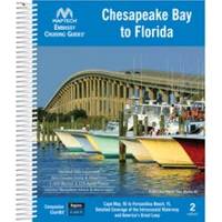
Embassy Cruising Guides - Chesapeake Bay to Florida #BKCBF-02
Model: BKCBF-02 Brand: Maptech
Cape May and Delaware Bay through the Chesapeake and Intracoastal Waterway to Fernandina Beach, FL. Packed with marinas, local navigation advice, aerial photos, and ICW Bridge Table. 560 pages. Use with Chartkit Regions 4 and 6. Product Overview Embassy Guides are the perfect navigation companion when you're planning your trip and underway. They're filled with detailed navigation advice and are an enjoyable read. Maptech offers four guides covering the East Coast of the U.S. from Maine to Florida, plus the Bahamas and Alabama. Designed for Ease of Use Find the information you need quickly. Harbors are indexed by chapters. Marina and facility locations cross-reference quickly with harbor chart segments. Even the crush-proof spiral binding and wrap-around covers are designed for easy page turning and bookmarking. Local Knowledge « less
Product Specification
-
Universal Product Identifiers
Part Number: BKCBF-02
Related Products
-
000-10932-001 OP10 Autopilot Controller
-
0100077300 Gpsmap536 Plotter
-
LMB-A1 F 2KW 4KW Raymarine Garmin Domes
-
Target Detection by Marine Radar [Book]
-
A67 5.7 Multifunction Radar Pack WE70077E92130A55077dA6236
-
000-10620-001 Triton Autopilot Computer - High Current
-
Deck Fill-Unmarked-Plain Bronze-Pipe Size 1-1/2 #0528008PLB
-
High Quality 8P8C RJ-45 Network Cable Crimper [HT-210C]
-
6ft Premier Series XLR Male to XLR Female 16AWG Cable (Gold Plated) [Microphone & Interconnect]
-
6ft Premier Series XLR Female to RCA Male 16AWG Cable (Gold Plated)
-
Southwest Wind Power 48 Volt Air Breeze Marine Turbine
-
409050-1 386ci Di Combo