CFHMPTN6 HotMaps Platinum Multi-Dimensional 3D Lake Maps
Model: CFHMPTN6 Brand: Navionics
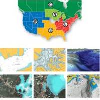
HotMaps Platinum offers 300 of Navionics exclusive high-definition lake maps featuring 1 contours, 3D bottom view, top-down photo/map overlay, and panoramic lake pictures. HotMaps Platinum series also offers 14,000 additional lakes with underwater structure, improved accuracy, major roads, county lines and more. HotMaps Platinum is compatible with most new Humminbird, Lowrance, Northstar, and Raymarine chartplotters. Please call for chartplotter compatibility. « less
Product Specification
-
Universal Product Identifiers
Part Numbers: 11094208, 37630, CF-HMPT-N6, DEF-257887-CFNO6GTIN: 00821245115706
Related Products
-
A67 Mfd Touchscreen wbuilt in Sonar No Charts E70077
-
JFE380 6 Inch Color LCD Sonar with Nkf341 Transducer and Matching Box
-
Tiller Autopilot St-1000+ A12004
-
Brass Chart Weight Clock & Pen Set
-
Lake Champlain Fishing North - Waterproof Charts
-
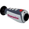
E70033 TH32 320 x 240 Thermal Marine Scope
-
10ft 14AWG Power Cord Cable w/ 3 Conductor PC Power Connector Socket (C13/5-15P) - Black
-
PH6625 Male Connector Phone
-
120-37 Yamaha (Late model) engine I/F
-
Goal Zero - Yeti 1250 1500w/1200w Portable Solar Generator 31901
-
1-AR30-10-48 Air 30 Wind Generator 12VDC
-
GPSMAP 441 - Marine GPS receiver - 4" color - 240 x 320