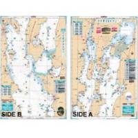
Lake Champlain Fishing North - Waterproof Charts
Designed for recreational boaters, fishermen and divers. Waterproof Charts are beautifully printed on synthetic paper. For use on deck in any weather rain or spray! Accurate, used by Coast Guard and Navy, simple to use with GPS. Foldable and easy to hold and store Waterproof Charts are so tear resistant you can't ruin them. Printed on both sides so they save you money! All Charts are 25"x38" This LARGE PRINT Lake Chart details all of the Major Fishing Areas and pinpoints dozens of specific areas for the major species caught in the area. (Large and Smallmouth Bass, Yellow Perch, Walleye, Muskie, Northern Pike, Salmon & Trout). Many areas have GPS positions. Grass and Marsh areas are also identified. Marinas are listed as well as popular Boat Ramps. Starting at Willsboro and Shelburne Points coverage is north to and including Missisquoi Bay and the Rt 202 Bridge on the Richelieu River in Canada. Includes Malletts Bay and all of the Champlain Islands. Information from 2 NOAA Charts: 14782 & 14781. This Chart is 25" X 38" and folded to 7"X14" « less
Product Specification
-
Universal Product Identifiers
Part Number: 12F
Related Products
-
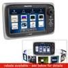
E7 7" Multifunction Display Internal GPS Canadian T70004
-
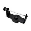
GPS receiver marine swivel mounting bracket
-
TX06S-1 - 6KW, 4' Open Array w/ 20m Cable
-
EW-C209 Furuno FP Format - Irish Sea
-
Max EN-M076 W21 Belgium Inland-River Rhein-MAX
-
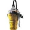
EPIRB Auto Release Cat I, No GPS EP50 Auto c30589
-
Smartpilot SPX-5R Sport Autopilot - E12220
-
VC 1 - Video cable
-
4634 3ft 2.5mm Stereo Plug/Plug M/M Cable - Black
-
Fiber Optic Cable, LC/LC, Multi Mode, Duplex - 3 Meter 2618
-
80404 Fuel Connector
-
Series 2010 Combo Masthead/All Round Lamp Fixed Mount, 4 Inch, 995003001