CFHMPTE6 HotMaps Platinum Multi-Dimensional 3D Lake Maps
Model: CFHMPTE6 Brand: Navionics
HotMaps Platinum Multi-Dimensional Lake Maps - with 1000 of Navionics exclusive high-definition lake maps to 1' contours featuring 3D bottom view, top-down photo/map overlay and panoramic lake pictures. FREE Fish'N Chip high-definition fishing detail for US Great Lakes waters now included in HotMaps Platinum Canada, North and East regions. Plus, over 15,000 additional lakes with underwater structure, improved accuracy, major roads, county lines and more. « less
Product Specification
-
Universal Product Identifiers
Part Numbers: 37632, CF-HMPT-E6, cw-37632, DEF-257887-CFEA6GTIN: 00821245135704
Related Products
-
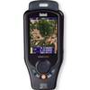
Onix350 HH GPS w/ Georeferenced Satellite Photos
-
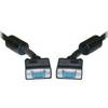
50 ft VGA cable 15 pin HD D-Sub (HD-15) - male - PC
-
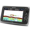
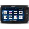
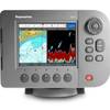
E97 Multifunction 9" Display with Sonar - aus, NZ, S. America, Asia Charts T70045 c44345
-
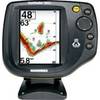
Fishfinder 340C - Fishfinder - included transducer - dual-beam
-
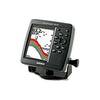
500 Series 585c - Fishfinder - included transducer : XNT-9-20-T - single-beam
-
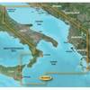
BlueChart g2 Vision - Adriatic Sea, South Coast - Maps
-
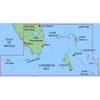
MapSource BlueChart - Southeast Florida - Maps
-
WPC074; Penobscot Bay Ed 1
-
E125 12" Multifunction Display w/ US Coastal Charts
-
HBL61CM22 - Straight Marine Adapter, 5-15P, L5-30R
-
3ft 24AWG Cat5e 350MHz UTP Bare Copper Ethernet Network Cable - Purple
-
E62188-IN A57D GPS Chartplotter / Fishfinder