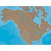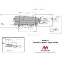
Cdr10 Digital Chart Kit Pr and US VI
Model: Cdr10 Brand: Maptech
Digital Chart Kit Puerto Rico and US Virgin Islands Contains all NOAA Charts in the title area, Coastal Topo Maps, Selected Navigation Photos, Aerial Pictures, Tides, Light Lists, Coast Pilot, Facilities are not included, Chart Navigator. The charts are BSB4 format-make sure your software is compatible. Digital ChartKit Digital ChartKit has all the software you need to get started in PC navigation. Each region includes GPS navigation software and charts on CD-ROM. Plan Before You Go Digital ChartKits include Offshore Navigator GPS planning and chartplotting software. Route planning is as simple as clicking a mouse. Click, and you've put the first waypoint on the chart. Click again and you're creating a route. It's that easy. Print Print route plans, tide and current graphs, and chart packets on standard home or office printers. GPS Ready Digital ChartKits « less
Product Specification
-
Universal Product Identifiers
Part Numbers: 32517, CDR10, cw-32517GTIN: 00608014703094
Related Products
-
MDS-1 2KW 12 Inch Dome Radar Add-on with 10 Meter Cable wmsd1
-
Max Lakes Canada C-Card NA-M048
-
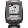
PiranhaMAX 150 - Fishfinder - included transducer : XNT-9-20-T - single-beam
-
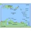
MapSource BlueChart - Southeast Caribbean - Maps
-
010-C0752-10 Bluechart G2 HAF452SKnysna Sa to Beira MZ Data
-
312800 Porthole 3 Instrument Plaque
-
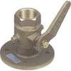
0805010PLB 2-1/2" Seacock Ball Valve Bronze
-
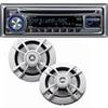
PKG-MR333 - Marine In-Dash Stereo & 6.5" 2-Way Speakers
-
SP-80MT Mechanical Dash Drive w/ Built in Feedback
-
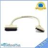
743 HPDB50 M/CN50 M SCSI Cable , 25pr - 1.5ft
-
(1) 100 Amp 125/250 Volt Connector to (2) 50 Amp
-
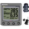
T22050-P ST60 Plus Tridata w/Removeable Thru Hulls