3206 Lake Mohave
Model: 3206 Brand: Fish-n-Map
FISH-N-MAP UNDERWATER TOPOGRAPHY MAPSMade of waterproof, tear resistant plastic. Features include: underwater depth contours, fish locations, latitude and longitude for GPS, multiple freshwater lakes on one map, boat ramps, recreational facilities and much more.
Product Specification
-
Universal Product Identifiers
Part Numbers: 032065, 249956, 3206GTIN: 00761428032065
Related Products
-
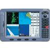
Colormax Pro 10.4" Chartplotter 29571
-
E12133 SmartPilot X-5 Wheel Corepack (No Control Head)
-
Mini CDC Chart F/ 1650-1850
-
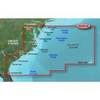
BlueChart g2 Vision - Mid-Atlantic - Maps
-
Cat6a Ethernet Cable | 3ft | Red | Network | 10 Gigabit
-
Power Bright 2 AWG 3 ft Battery Cables
-
30ft 24AWG Cat6 550mhz UTP Ethernet Bare Copper Network Cable - Orange
-
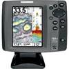
700 Series 787c2i Combo - Marine Chartplotter - 5" color - 640 x 480
-
15ft USB 2.0 A Male to Mini-B 5pin Male 28/24AWG Cable w/ Ferrite Core (Gold Plated)
-
30ft 24AWG Cat5e 350MHz UTP Bare Copper Ethernet Network Cable - Gray
-
Marine Products Plug Wire Set 9-28054
-
898c Si 7" Color Side Imaging Fishfinder/GPS