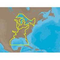
30128 Max - U.S. Gulf Coast and Inland Rivers - C-Card
Model: 30128 Brand: C-Map
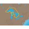
NA-M023 => Gulf of Mexico, Great Lakes and Rivers Coverage of the Gulf states, starting from Boca Raton, FL, down to Key West, FL, then back up and around the Gulf to Brownsville, TX. Also includes coverage of all the Great Lakes: Erie, Superior, Ontario, Huron and Michigan. Coverage of the Great Lakes also includes Fox River and Lake Winnebago, Lake St. Clair and the Trent-Severn Waterway. River coverage includes the Mississippi River, Ohio River, Illinois River, Arkansas River, Red River, Ouachita River, Tennessee River, Cumberland River, Tenn-Tom Waterway and the Black Warrior River. Other smaller rivers are also included: Green River, KY, Kanawha River, WV, Allegheny and Monongahela Rivers, PA and Kankakee River, IL. Additional coverage of the Hudson River, including Lake Champlain, down to New York City, the Erie Barge Canal and partial coverage of the St. Lawrence River up to Montreal. « less
Product Specification
-
Universal Product Identifiers
Part Numbers: 30128, NA-M023, NA-M023.00, NA-M023C-CARDGTIN: 000000165837, 00686074002739
Related Products
-
DSM250 Basic GPS with Display & Cable Black Pkg-13B
-
SD699P N Bahamas Plat + on M155-Sd
-
NA-C101 C-Card Format - Superior, Huron, No Chan Grgn
-
Safelink GPS EPIRB with Manual Bracket 10-K1202311
-
Marine Navigation Lights for Boats to 65'7" Starboard Series
-
SP110VF-9 SP-110 System w/Virtual Feedback & Mechanical Remote
-
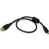
1.5ft USB 2.0 A Male to Mini-B 4pin Male 28/24AWG Cable w/ Ferrite Core (Gold Plated)
-
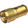
Nm8x-g Male N Connector for RG-8X Cable
-
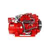
10.0 Sbeg Generator
-
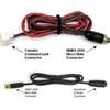
MARE-002 - Adapter, Yamaha Cmnd Link to Micro Fem
-
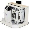
FCF-12000 Feel Cool Fast Marine Air Conditioner by Webasto
-
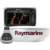
T70103 e7D 7" Multifunction Display w/Sonar, Internal G