010-C1025-20 Bluechart G2 HXEU718LMediterranean Sea Microsd/sd
Model: 010-C1025-20 Brand: Garmin
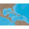
See your surroundings more clearly with BlueChart g2 data. With BlueChart g2, you’ll get detailed marine cartography that provides convenient viewing of nautical content. BlueChart g2 allows you to see your vessel’s precise, on-chart position in relation to naviads, coastal features, anchorages, obstructions, waterways, restricted areas and more. You will also have access to detailed mapping capabilities that include Safety Shading, Fishing Charts, smooth data transition between zoom levels, harmonious transition across chart borders, and reduction of chart discontinuities. Covers: Detailed offshore coastal coverage of the Mediterranean Sea in its entirety. Coverage features the Strait of Gibraltar, the Balearic Islands, the French Riviera, Corsica, Sardinia, Sicily, the Adriatic Sea, the Greek Islands, the Aegean Sea, the Dardanelles and Bosporus Straits, the Sea of Marmara, Cyprus, the Suez Canal, Tripoli and Algiers Harbors, and the Gulfs of Gab « less
Product Specification
-
Universal Product Identifiers
Part Numbers: 010-C1025-20, 10807295, 35822GTIN: 00753759096250
Related Products
-
T92181 RD418D 4KW 18 Inch Dome with Cable
-
NA-C401 C-Card Format - St. Lucie Inlet LK Pontch
-
The Nautical Chart Movie Photo Print (11 x 17)
-
BlueChart g2 Vision - South Maine - Maps
-
GPSMAP 6012 - Marine Chartplotter - 12.1" color - 1024 x 768
-
BlueChart g2 Vision - Golfe Du Lion to San Remo - Maps
-
010-C0764-10 Bluechart G2 HEU005RIreland West Coast Data Card
-
E62184 - A50 5 Chartplotter, Int GPS, w/o Maps
-
40300-7 S40 Port Navigation Light 12v/25w
-
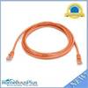
7ft 24AWG Cat5e 350MHz UTP Bare Copper Ethernet Network Cable - Orange
-
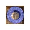
Bulk cable - CAT 5e - Unshielded twisted pair (UTP) 1000 ft - Purple
-
Marine Products Plug Wire Set 9-28011