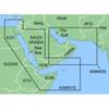
010-C1023-20 Bluechart G2 HXEU802XMediterranean Sea & Iberian
Model: 010-C1023-20 Brand: Garmin
NOTE: This preloaded Garmin microSD media is for compatible Garmin units that take microSD memory cards only. This is not for units that require the Garmin proprietary data card. Coverage features the Strait of Gibraltar, the Balearic Islands, the French Riviera, Corsica, Sardinia, Sicily, the Adriatic Sea, the Greek Islands, the Aegean Sea, the Dardanelles and Bosporus Straits, the Sea of Marmara, Cyprus, the Suez Canal, Tripoli and Algiers Harbors, and the Gulfs of Gabes and Tunisia. Also details the Atlantic side of the Iberian Peninsula from the Canary Islands to the Bay of Biscay including the Gulf of Cadiz, the Portugal coast in full, the Gulf of Gascogne, and the Madeira and Azores Islands. « less
Product Specification
-
Universal Product Identifiers
Part Numbers: 010-C1023-20, 10807253, 35817GTIN: 00753759095529
Related Products
-
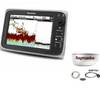
Package(c97 with USA Coastal Chart, 4KW 24 Inch Digital Radome & Radar Cable)
-
Package(c127 with aus, NZ, S. America, Asia Chart, 4KW 24 Inch Digital Radome & Radar Cable)
-
GRH4D HD Ethernet Radar Dome 21" 40381
-
RSB0073-087 24/48 rpm Gearbox with 25.0 KW Transceiver (FR8252)
-
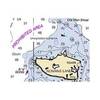
MapSource BlueChart - Red Sea - Maps
-
NOAA Dixon Entrance-Cape St. Elias
-
25ft VGA to 3 RCA Component Video Cable (HD15 - 3-rca)
-
250ft 18AWG CL2 Rated 2-Conductor Loud Speaker Cable (for In-Wall Installation)
-
12ft 22AWG 5-rca Component Video/audio Coaxial Cable (RG-59/U) - Black
-
12.5 Beg Generator
-
E55058 High SeaTalk Speed Network Switch
-
lian M2-TD02 I-Series Dish Network Multi-Satellite Interface Mult