010-C0728-10 Bluechart G2 HUS027RHawaiian Islands Mariana
Model: 010-C0728-10 Brand: Garmin
Coverage of the Pacific Ocean from the Hawaiian to Mariana Islands. Includes coverage of Guam, Midway, and Johnston Atoll. General coverage of Palmyra Atoll and the Marshall Islands also included. See your surroundings more clearly with BlueChart g2 data. With BlueChart g2, you'll get detailed marine cartography that provides convenient viewing of nautical content. BlueChart g2 allows you to see your vessel's precise, on-chart position in relation to naviads, coastal features, anchorages, obstructions, waterways, restricted areas and more. You will also have access to detailed mapping capabilities that include Safety Shading , Fishing Charts , smooth data transition between zoom levels, harmonious transition across chart borders, and reduction of chart discontinuities. « less
Product Specification
-
Universal Product Identifiers
Part Numbers: 010-C0728-10, 10469849, 35558, GAR010C072810GTIN: 00753759089290
Related Products
-
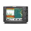
1158c High Definition External GPS & Fishfinder with Transom Mount Transducer 39688
-
CANNON 408560-1 21" Radar 4KW 24 rpm
-
Package(c127 with aus, NZ, S. America, Asia Chart, 4KW 24 Inch Digital Radome & Radar Cable)
-
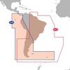
Max Electronic Chart - South America - Costa Rica to Chile & The Falklands, Wide Coverage SA-M500
-
Howe Sound Chart
-
2775.91 FBRS 2775 Battery Replacement Service
-
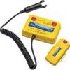
Autotether 100-A-01 Wireless Lanyard
-
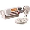
RADIO-FIX VHF Class-D DSC Wht
-
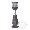
T-Top Fold-Down Navigation Boat Light
-
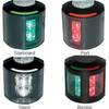
Series 43 Black LED Navigation Light Port
-
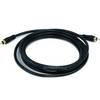
6303 10ft Coaxial Audio/Video RCA Cable M/M RG59U 75ohm (for S/PDIF, Digital Coax, Subwoofer & Composite Video)
-
408930-1 Ice 597ci HD Combo