Ecdis
-
Navi-Sailor 4000 ECDIS
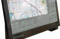
PurposeECDIS is a computer-based navigation information system compliant with International Maritime Organization (IMO) regulations and can be used as an alternative to paper nautical charts. An ECDIS system displays the information from electronic navigational charts (ENC) and integrates position information from the Global Navigation Satellite System (GNSS), gyrocompass, speed log, other navigational sensors, radar and automatic identification systems (AIS). Transas delivers a full range of type-approved ECDIS solutions that can be stand-alone or part of the Integrated Navigation Systems or Multifunctional Display i.e. Radar, Conning, Alarm Management, Track Control in one workstation. Transas ECDIS provides easy and unique possibilities for customization.Standard/Standard+ - Premium/Premium+Each system includes a carefully selected range of standard features, with an extensive range of additional hardware and software options. So whether you 19re just beginning your ECDIS journey or seek the ultimate level of information at your fingertips, Transas offer something for every ECDIS user.Advantages The world 19s number one ECDIS User friendly navigation tool Most evolved ECDIS on the market Flexible configuration 4-level ECDIS solutions to suit all customers MFD functionality and network capability Consistent graphic user interface (GUI)
-
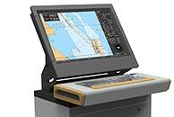
Navi-Sailor 4000 ECDIS MFD Premium/Premium+
Every Transas MFD workstation (WS) can be equipped with a standard set of software such as ECDIS, Radar, Conning, Chart Assistant utility and SPOS weather module giving the mariner the ability to switch between applications at the touch of a button. All the aforementioned applications are running simultaneously as part of the Multifunction Display.FunctionalityNavi-Sailor 4000 ECDIS MFD is available in two packages: Marine LED Display Transas RS6 computer Transas ES6 Keyboard Transas ES6 Trackball Navi-Sailor 4000 ECDIS Software Basic ECDIS Functions Docking Mode Reference points for mooring operations Dual Chart Panel Left Chart Panel (conning) Special Purpose Objects Target Simulator Trial Maneuvering Ports DB Quick distance calculator Configuration of Local Workstation New GUI and Bridge Configuration (June 2012) AIO 13 Additional information Overlay Additional Chart Formats Additional Route Planning Functions Additional Sensors AIS, ARPA and Target Management ARPA B (second ARPA) Target simulator Tides & Currents Playback Maps (User Charts) Navtex Interface Premium+ pack brings the following additional advanced functions: Trial Maneuver Precise Nav Tools 13 Predictor/Route AIS RDVZ/CHL Advanced planning functions E-Log book Navi-ConningFor both Premium and Premium+ an extensive range of additional hardware solutions and software options are available.AdvantagesSafe Navigation and Easy OperationProvides all the information you need, via a user-friendly and intuitive menu system.Information System and Decision SupportA continual flow of information for presentation of the crucial and most needed navigational information and objects.Choice and CustomizationNew and practical options enable system customization, including multiple operation modes with charts in up to 7 different formats.Sensor IntegrationConnects all available onboard navigation data sensors and systems, such as: two positioning systems, gyro, log, two ARPAs, AIS, echo sounder, autopilot, navtex and more. Planning and Forecasting Includes powerful tools for passage planning, weather routing and calculation, and environmental tide and current databases. Weather forecasts, with the optional SPOS weather and route planning tool, are integrated with NS 4000.SavingsDirect effects on fuel consumption, voyage times & work time.Integration Navigator-friendly environment for One Man Bridge operation reduces workload and stress; Clear and consistent man-machine interface for intuitive and convenient operation; Enhanced functional integration of navigational data; System redundancy: all functions of ECDIS, Radar and Conning can be available on all MFD 19s onboard; Palettes synchronization in all 3 applications; Sensor redundancy and double network ensures data integrity and reliability for network configuration; Intelligent and efficient alarm management; Simultaneous Loaded Route monitoring in ECDIS, Radar & Conning; ECDIS Master Station status changeover to any MFD station; Distribution of radar pictures from all available radars within MFD network; Chart correction, route and user database synchronization at all workstations and applications; Order charts, charts corrections and weather forecasts online via ship communication station protected by firewall.
-
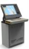
Navi-Sailor 4000 ECDIS Standard/Standard+
Standard and Standard+ are the entry-level system from Transas and meet all IMO and SOLAS ECDIS regulations. You can benefit from advanced technology in a simple package along with the quality and service expected from Transas. Navi-Sailor 4000 ECDIS is a navigation information system that displays full positional information from navigation sensors on electronic navigational charts. The system is designed to assist the officer in charge of the navigational watch (OOW) in route planning and monitoring.Functionality 24 1D Marine Panel Computer; Transas ES6 Trackball; Navi-Sailor 4000 ECDIS Software; Basic ECDIS Functions.The Standard+ pack brings the following additional planning and information functions: Additional Chart Formats; Additional Route Planning Functions; Additional Sensors; AIS, ARPA and Target Management; Tides & Currents; Playback; Maps (User Charts); Navtex Interface.An extensive range of additional hardware solutions and software options are available for both Standard and Standard+.
-
Navi-Planner 4000
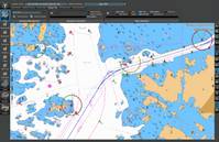
Navi-Planner 4000 sets a new standard for safe and efficient voyage planning. This innovative solution from Transas provides a single access point for all information needed for every step of the navigation process When developing the Navi-Planner 4000, Transas worked closely with oil company vetting-inspectors, ship owners and navigation officers. The result is a tool which makes voyage planning easy for navigators and efficient for ship owners. Navi-Planner 4000 complies with IMO Resolutions (IMO 1.916(22) Guidelines for the recording of events related to navigation and IMO A.893(21) Guidelines for Voyage Planning).PurposeNavi-Planner 4000 is recognized as the ECDIS markets most powerful charts management application, and also a set of databases, applications and services intended for voyage planning. Suitable both onboard as a 19back of the bridge 19 application, and ashore as a management tool Navi-Planner 4000 software creates a voyage plan using an electronic route editor, including: Port to port planning of a complete voyage plan AtoBviaC auto routing Under Keel and Over Head Clearance Route checking Reference point selection Reporting points Warnings along the route Chart listings for both (S)ENC and paper charts Detailed voyage plan reports Route export/import Integration with Navi-Sailor 4000 ECDIS Online correction service for paper charts and publications via TGT ServicesApplications and ServicesQuick Route with AtoBviaC distance tables 1CAtoBviaC distance tables 1D is a unique and powerful tool for basic route navigation planning. The routes are based on BP Distance Table and can be used for quick distance calculation, as a good tool for chart selection for (S)ENC Pre-licensing and as a basis for detailed route and voyage planning with Navi-Planner. 1CAtoBviaC distance tables 1D contains virtually thousands of alternate routes and a set of route calculation rules that can be set on/off by the navigator when setting up the route calculation.Weather FunctionalityThe Weather Functionality in Navi-Planner is a service to assist the mariner on board in making the best decisions with regards to voyage planning in relation to weather conditions.Advantages of onboard weather routing: Fuel and speed optimization Safety of crew and cargo Situational awareness Costs for meteorologists on shore are reduced Reduced administration onboard and in the officeThe weather data is supplied by Meteo Consult, a meteorological office that prepares a complete set of accurate weather information for standards ocean regions and coastal waters.The data includes air pressure, wind and wave forecasts but also tropical storm forecasts, temperatures, precipitation, ice limits and much more.Chart ordering and managementTransas offers a unique way of ordering and handling charts thru Navi-Planner. It can either be used for pre-licensing charts or as a Pay as you sail (PAYS) service. If pre-licensing is used, selection of charts to order can easily be made by a created route or a route loaded from the AtoBviaC auto routing functionality. The operator can select whether he wants to receive the license/permits only or receive the complete chart content from the server. During the preparation of the order a selection of license period can be made and the approximate cost of the order will be indicated.Once the charts are received and installed, Navi-Planner will display a status report and thensynchronize the data to any other Workstation within the network.If PAYS is used, a license holding all available PAYS SENC/ENCs is used and only charts that have been used for navigation will be charged.Chart correction and managementAs part of the chart management functionality in Navi-Planner, chart corrections can be ordered, installed and recorded both for (S)ENC 19s and paper charts. It is imperative for the Master to always have full control and overview for the vessels chart holdings and to be able to show this to authorities and inspectors.As Navi-Planner operates with the Transas Chart Server directly or via email it offers the easiest way to access updates for charts used onboard.Detailed waypoint and voyage planningTransas Navi-Planner is as very powerful route planning tool. It is capable of everything from basic and simple route creation to full 1Ctrack control level C 1D planning as well as Route checking and 1CUnder Keel Clearance 1D (UKC) calculations based on set ships and safety parameters.The main parts and functionality for route planning are for route geometry, schedule, additional information along the route as reference points, and metrological as well as hydrological data Routes, waypoints, Cross Track distances (XTD) and reference points can be created and edited either graphical or tabular. Route legs can be selected individually to be Rhumb-line Great-Circle based on WGS-84. Schedules can be calculated with or without speed limits for each route leg and including surface and tidal currents in the calculation.Paper chart correctionsDid you know that Navi-Planner 4000 is not only capable of managing electronic charts and publications as part of your passage planning but also paper charts and paper publications. Within the program you can easily import your complete inventory or manually make a selection of paper charts held onboard. Navi-Planner can then directly connect to the Transas chart server ashore to gather all outstanding Notices to Mariners. You will get a clear overview of the status for your paper charts and any paper chart that may be used during your next voyage will automatically be listed in the passage plan, very easy and very safe.Piracy Information OverlayTransas 18Piracy Information Overlay 19 brings you credible piracy intelligence from recognised sources around the world. Using Navi-Planner, the piracy events for the last 365 days are available to view 24/7 as an information overlay to complement your existing company account features. Piracy Information Overlay provides the user with up to date information, essential for planning avoidance measures when travelling through a potential piracy area. The PIO data service is automated and updated at a minimum of 24 hour intervals.Advantages The market 19s fastest and most powerful chart management application Everything you need for voyage planning and navigation management Digital services managed in one application Built-in paper chart and publication corrections Full voyage planning, port-to-port and berth-to-berth Developed through co-operation with customers and authorities Made to support ISM procedures and bridge administration