The Sea Chart: The Illustrated History of Nautical Maps and Navigational Charts [Book]
The sea chart was one of the key tools by which ships of trade, transport and conquest navigated their course across the oceans. John Blake looks at the history and development of the chart and the related nautical map, in both scientific and aesthetic terms, as a means of safe and accurate seaborne navigation. This handsome work contains 150 color illustrations including the earliest charts of the Mediterranean made by early thirteenth-century Italian merchant adventurers, as well as eighteenth-century charts that became strategic naval and commercial requirements and led to Cook's voyages in the Pacific, the search for the Northwest Passage, and races to the Arctic and Antarctic. « less
Product Specification
-
Authors: John Blake, Lie LiePages: 160Format: paperbackPublication Date: September 1, 2009
-
Universal Product Identifiers
ISBN: 1591147824GTIN: 09781591147824
Related Products
-
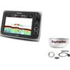
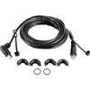
Package(e97 with USA Coastal Chart, 4KW 18 Inch Digital Radome & Radar Cable)
-
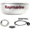
T92182 RD424D 4KW 24 in Dome with Cable
-
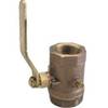
Inline Valve, 1 Inch Pipe
-
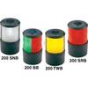
Base Mount White Masthead Navigation Lights Light, 225
-
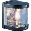
Series 25 Classic Starboard Navigation Light
-
6ft Premium Optical Toslink Cable w/ Metal Fancy Connector
-
3939 18inch SATA 6Gbps Cable - UV Blue
-
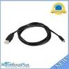
106 6ft USB 2.0 A Male to Mini-B 4pin Male 28/28AWG Cable
-
Split Connector 20ft Right Angle RJ45 Plug
-
83A 30A Locking to 15A Straight Blade Adapter
-
Marine Products Plug Wire Set, Mercruiser V-8, 9-28001
-
PMF-5R-7L 5 inchPowermount for Raymarine Domes Forward Lean with Light Bracket Option PMF-5R-7L (PMF-57-M1 + ADA-R1) wpmf5r7l