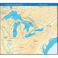
NT+ Wide Map, Lake Huron/Georgian Bay/North Channel NA-C104
Model: NA-C104 Brand: C-Map
C-MAP has set the standard for electronic charts with five consecutive NMEA awards for "Best Electronic Cartography". Built on the incredible success of C-MAP NT+, NT+ Wide combines a generation of chartplotters with efficient performance plus real-time accuracy and detail. Now you will be able to see slip detail as well as the locations for onshore facilities. « less
Product Specification
-
Universal Product Identifiers
Part Number: NA-C104GTIN: 00686074003071
Related Products
-
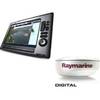
Package(E140W, GPS Antenna, 4KW 24 Inch Digital Radome & Radar Cable )
-
Studio Arts Kids Under The Sea Growth Chart GCUS-01W
-
Pipe Dk Plt 1.25 PLB - Buck Algonquin
-
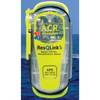
2881 ResQLink Plus PLB375
-
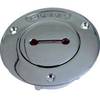
Deck Plates, Fills for Pipe, 3", Unmarked, Bronze
-
Cat6a Ethernet Cable | 35ft | White | Network | 10 Gigabit
-
7ft 24AWG Cat6 550mhz UTP Ethernet Bare Copper Network Cable - Green
-
1ft 24AWG Cat5e 350MHz UTP Bare Copper Ethernet Network Cable - Gray
-
6ft DB-25(IEEE-1284) Male to Mini/Micro Centronic 36(hpcn36) Male Cable [IE]
-
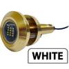
Lumishore Thru Hull Flush Fit 18 Watt Blue Underwater Light
-
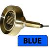
Lumishore Thru-Hull Underwater Light - Blue - 120W
-
500ft Bulk, Marine Network Cable, RJ45