NA-M024 SD Card Format US West Coast and Haw
Model: NA-M024 Brand: C-Map
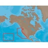
NA-M024 => USA West Coast and HawaiiCoverage of the Pacific Coast of the United States, including all of the coasts of California, Oregon and Washington. Coverage of Baja California and Mexico down to Puerto Vallarta. Detail of the Columbia River, Sacramento River, Willamette River. Snake River and San Joaquin Rivers are also included. Full coverage of Puget Sound and the San Juan Islands up to Point Roberts is also included. Additional coverage of the Hawaiian Islands out to Midway and Johnston Atoll is also included. « less
Product Specification
-
Universal Product Identifiers
Part Numbers: 30147, CMANAM024SD, M-NA-M024, NA-M024-SD, NA-M024SDCARDGTIN: 000000165847, 00686074002746
Related Products
-
Sonar X-100c, X105cdf, X-136df, X-135, X-126DF, X-125, X67C Sonar [DVD]
-
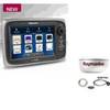
Package(e7 with aus, NZ, S. America, Asia Chart, 4KW 24 Inch Digital Radome & Radar Cable)
-
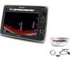
Package(e127 with USA Coastal Chart, 4KW 18 Inch Digital Radome & Radar Cable)
-
010-C0728-20 Bluechart G2 HXUS027RHawaiian Islands - Mariana
-
Edupress EP-2520 Sea What We Can Do Incentive Chart
-
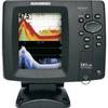
587ci HD Di Fish Finder GPS Combo #408480-1
-
Marine Navigation Workbook: Piloting and Celestial and Electronic Navigation [Book]
-
6ft Premier Series XLR Female to RCA Male 16AWG Cable (Gold Plated)
-
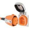
SmartPlug B30ASSY 30 Amp Marine Shore Power Inlet & Connector
-
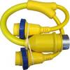
LTD A3030Y50H 50 Amp to 30 Amp Y-Adapter
-
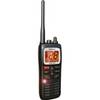
Submersible Hand-Held 2-Way VHF Marine Radio Uniden MHS125
-
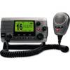
34170 Vhf-200 VHF Radio W/class-d DSC