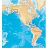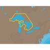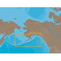
NA-C802 Furuno FP Format Gulf of Alaska
Model: NA-C802 Brand: C-Map
With are Electronic Sharts C-Maps we have: Olympia, Washington to Port Mcneill, British Columbia. Nannose to Victoria to Cape Scott Texada Island to Caamano Sound Cape Caution to Portland Canal Banks Island, British Columbia to Sumner Strait, Alaska Dixon Entrance to Icy Bay Gulf of Alaska Western Alaska NA-C802 Gulf of Alaska NT+ Cartography NT+ electronic charts feature much wider coverage areas at substantially lower prices. « less
Product Specification
-
Universal Product Identifiers
Part Numbers: 20185, NA-C802, NA-C802FURUNOFPGTIN: 00686074002258
Related Products
-
U1-200N-000 SE-200 BB Sonar w/o Ducer Includes VGA & Video
-
E97 Multifunction 9" Display with Sonar - European Charts T70043 c44344
-
BR24 Broadband Radar 10M Cable for HDS-Series #AA010214
-
11094018 Map, Nova Scotia-st Lawrence River
-
NA-C101 C-Card Format - Superior, Huron, No Chan Grgn
-
The Nautical Chart: A Novel of Adventure [Book]
-
6.6 ft DVI cable - dual link 24 pin digital DVI - male - PC
-
40500-7, Series 40 Stern Black HSG
-
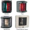
Marine 3562 Series Navigation Lights Starboard Light, 1nm
-
3ft RG6 (18AWG) 75OHM, Quad Shield, CL2 Coaxial Cable with F Type Connector - White
-
F-Splice-CP/GH-01 Connector for RG-6U Cable
-
Matrix 12 - Fishfinder - included transducer : XNT-9-20-T - single-beam