Marine World Chart of Nicolo de Canerio Januensis [Book]
This historic book may have numerous typos and missing text. Purchasers can download a free scanned copy of the original book (without typos) from the publisher. Not indexed. Not illustrated. 1908 Excerpt: ...by chance, the expedition of Pinzon. His voyage carried him as far as the coast of Paria, whence he returned, reaching Palos in November, 1500.2 The 9th of March, 1500, Pedro Alvarez Cabral left the port of Lisbon with thirteen vessels bound for Calicut. It may have been by accident that he touched the coast of Brazil, April 22d, at a point near the present Monte Paschoal. He appears to have sailed as far north as the present Porto Seguro, and from this point Cabral departed for the Cape of Good Hope to continue his voyage to Calicut, but Gaspar de Lemos was sent back to Portugal to carry the word of the discovery of a land to which the name Terra de Santa Cruz was given.3 Rodrigo de Bastidas sailed in October, 1500, under letters patent dated June 5, 1500, to discover "islas e tierra-firme a las partes de las Indias, o a otra cualquier parte, con tal que no sea de las islas e tierra-firme que fasta aqui son descubiertas por Cristobal Colon e por Cristobal Guerra." It appears that Andreas de Morales and Juan Rodriguez, pilots, sailed with him, as did also Juan de la Cosa. He first touched the mainland at some point along the Cumana coast, sailed thence westward, at least to the Gulf of Darien and perhaps as far as Puerto del Retrete, including the entire coast of Panama. This part of the New World, however, Canerio omits from his chart. He returned in September, 1502.1 'Navarrete, 1. c., Vol. Ill, p. 547; Venetia, 1556, Vol. I, pp. 132-139; Peter Martyr, 1. c., Decades, I, Lib. ix. Humboldt: Kritische Untersuchungen 2 Las Casas, 1. c., Vol. II, pp. 442, uber die historische Entwickelung der 453; Navarrete, 1. c., Vol. Ill, pp. 23, geographuchen Kenntnisse von der 544, 553. neuen Welt (Ideler's translation from "Ramusio: Navigations et Viaggi, ... « less
Product Specification
-
Authors: Edward Luther StevensonPages: 24Format: paperbackPublication Date: May 18, 2012
-
Universal Product Identifiers
ISBN: 1236149696GTIN: 09781236149695
Related Products
-
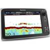
T70037 C127 Multifunction Display W Sonar - US Inland Chart
-
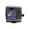
531s - Transducer - included transducer - dual-beam
-
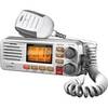
Solara D UM380 Fixed Mount Class D VHF Marine Radio
-
Marinenav Barracuda 1.5 Marine Navigation PC Computer BAR-151
-
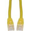
Cat6a Ethernet Cable | 2ft | Yellow | Network | 10 Gigabit
-
A3015S 125VAC - 30 Amp -to- 125VAC - 15 Amp Straight ad
-
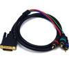
3.25ft DVI-I to 3 RCA Component Video Cable (DVI-I - 3-rca)
-
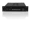
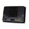
000-10290-001 - NSO System, Processor Only
-
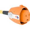
SmartPlug BF30 30 Amp Marine Shore Power Connector
-
Wiring Device-Kellems HBL63CM64 Connector Body,50 A 3D977
-
T-H Marine Drain Plug - Black (Bulk) THM-DP1
-
3ft 24AWG Cat5e 350MHz UTP Bare Copper Ethernet Network Cable - Pink