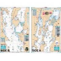
Lake Champlain Fishing North - Waterproof Charts
Designed for recreational boaters, fishermen and divers. Waterproof Charts are beautifully printed on synthetic paper. For use on deck in any weather rain or spray! Accurate, used by Coast Guard and Navy, simple to use with GPS. Foldable and easy to hold and store Waterproof Charts are so tear resistant you can't ruin them. Printed on both sides so they save you money! All Charts are 25"x38" This LARGE PRINT Lake Chart details all of the Major Fishing Areas and pinpoints dozens of specific areas for the major species caught in the area. (Large and Smallmouth Bass, Yellow Perch, Walleye, Muskie, Northern Pike, Salmon & Trout). Many areas have GPS positions. Grass and Marsh areas are also identified. Marinas are listed as well as popular Boat Ramps. Starting at Willsboro and Shelburne Points coverage is north to and including Missisquoi Bay and the Rt 202 Bridge on the Richelieu River in Canada. Includes Malletts Bay and all of the Champlain Islands. Information from 2 NOAA Charts: 14782 & 14781. This Chart is 25" X 38" and folded to 7"X14" « less
Product Specification
-
Universal Product Identifiers
Part Number: 12F
Related Products
-
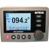
AP80 Autopilot Control Unit 000-10181-001
-
NAVPILOT720OB Autopilot
-
GPSMAP 76Cx - Marine, hiking GPS receiver - 2.6" color - 160 x 240
-
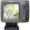
HDS-8 Base Mltfnc Fishfinder/Chartplotter w/ 83/200 K 34255
-
HDS-5 Lake Insight Multifunction w/o Trans 34242
-
Package(c97 with aus, NZ, S. America, Asia Chart, 4KW 18 Inch Digital Radome & Radar Cable)
-
Chart Master Pro Combo - Internal Antenna U1-CHRT-PROI
-
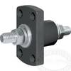
1-1 4 in. IPS Intake Strainer Bronze Made in The USA
-
700 Series 788ci Combo CHO - Marine Chartplotter - 5" color - 640 x 640
-
SP36-5 Autopilot w/ Rate Comp Rotary Feedback 18CI Pump
-
2205 Black Terminal Feed Through Connector
-
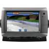
GPSMAP 720 - Marine Chartplotter - 7" color - 800 x 480 - widescreen