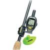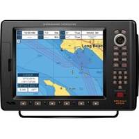
CP590 12 GPS Chartplotter w/Coastal Charts Map
Model: CP590 Brand: Standard Horizon
CP590 - WAAS GPS Chart Plotter External Antenna with built-in C-Map Cartography Find every destination in style with the CP590 WAAS enabled GPS Chart Plotter. Preloaded with detailed maps for coastal navigation of USA including Alaska, Hawaii and Great Lakes, Canada, Bahamas, Caribbean, Cuba, Mexico, Puerto Rico, and Central America. Providing up to 10-foot accuracy the CP590 is designed to navigate you quickly and accurately to your destination. The CP590 boasts a crisp high-definition 12-inch 800x600 (SVGA) sunlight viewable TFT display. The 5 user programmable hot keys allow quick and easy access to a number of preprogrammed navigation displays. Connect your CP590 to two video sources and watch your favorite DVD, play your favorite video game, or monitor your engine room in full screen or Picture in Picture. In addition, the CP590 has one VGA Video output that connects to an external TV or Monitor allowing your passengers to view the vessels progress to a favori « less
Product Specification
-
Universal Product Identifiers
Part Numbers: 40777, CP500, CP590, DEF-258647GTIN: 00788026126040
Related Products
-
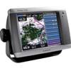
010-N0593-01 - GPSMAP 5208 Noh Chartplotter w/GPS Ant
-
GPSMAP 441s GPS Combo T/M D/F Reman Noh
-
385cxi Fishfinder GPS Combo - International Unit
-
LX-7 Color LCD Sonar
-
e7D 7" Multifunction with Sonar and Canadian Charts T70009
-
SmartCast RF25 - Fishfinder - portable - included transducer : RF45 - single-beam
-
White All-Round Light
-
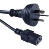
Cable Showcase Austrailian Power Cord UL/CSA, 6 ft
-
Trident Marine Hose 5" x 6" Fiberglass Splicer
-
2708 Cover for 600 Amp Cable Connector
-
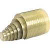
18-8082 1/4 in. NPT Fuel Tank Connector
-
1ft 24AWG Cat6 550mhz UTP Ethernet Bare Copper Network Cable - Red