5209; Map-Roosevelt Lake
Model: 5209 Brand: Fish-n-Map
FISH-N-MAP UNDERWATER TOPOGRAPHY MAPSMade of waterproof, tear resistant plastic. Features include: underwater depth contours, fish locations, latitude and longitude for GPS, multiple freshwater lakes on one map, boat ramps, recreational facilities and much more.
Product Specification
-
Universal Product Identifiers
Part Numbers: 250137, 5209GTIN: 00761428052094
Related Products
-
XN13A/6 - 6 Foot Open Array Antenna
-
SG1 Marine Weatherproof CD Player Face Cover
-
NA-C301 C-Card Format Passamaquoddy NARRAGAN
-
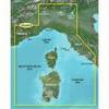
BlueChart g2 Vision - Ligurian Sea, Corsica and Sardinia - Maps
-
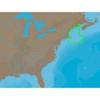
Max Electronic Chart, Wide, South-West European Coasts, DVD, M-EM-M076
-
FBRS 2775 Battery Service Includes 1096 Batt Parts Labor
-
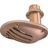
0065DP4PLB 1/2 Scoop Thru Hull w/Nut
-
Shore Power Cable 6/4 White Per ft
-
15ft USB A to Mini-B 5pin 28/28AWG Cable
-
Cat6a Ethernet Cable | 15ft | White | Network | 10 Gigabit
-
5ft 24AWG Cat5e 350MHz UTP Ethernet Bare Copper Network 3375
-
MPC-122-K Series: X86 Marine Panel computers with Intel Core 2 Duo 2.26 GHz, VGA, 2 Gigabit LANs, CompactFlash