Hydrographical Surveying: A Description of the Means and Methods Employed in Construcing Marine Charts [Book]
Unlike some other reproductions of classic texts (1) We have not used OCR(Optical Character Recognition), as this leads to bad quality books with introduced typos. (2) In books where there are images such as portraits, maps, sketches etc We have endeavoured to keep the quality of these images, so they represent accurately the original artefact. Although occasionally there may be certain imperfections with these old texts, we feel they deserve to be made available for future generations to enjoy. « less
Product Specification
-
Authors: W. J. L. (William James Lloyd) WhartonPages: 418Format: paperbackPublication Date: 2012.08
-
Universal Product Identifiers
ISBN: 1290730547GTIN: 09781290730549
Related Products
-
Package(c97 with aus, NZ, S. America, Asia Chart, 4KW 24 Inch Digital Radome & Radar Cable)
-
Marine LED Chart Red Light White Cvr 400 HLL-343720142
-
2744.91 FBRS 2744 Battery Replacement Service
-
M72 Handheld VHF Radio 220V #IC-M72 220V
-
M802 Digital Marine SSB Radio c14862
-
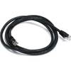
25ft 24AWG Cat6 550mhz UTP Ethernet Bare Copper Network Cable - Purple
-
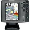
700 Series 787c2i Combo - Marine Chartplotter - 5" color - 640 x 480
-
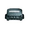
InterLink - Fishfinder InterLink system connection module
-
5ft 24AWG Cat5e 350MHz UTP Ethernet Bare Copper Network 3375
-
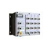
MPC-122X-K Marine PC
-
Cat6a Ethernet Cable | 15ft | Black | Network | 10 Gigabit
-
Meridian - Marine, hiking GPS receiver - Monochrome - 120 x 160