4123 La &Amp; Orange County Inshore
Model: 4123 Brand: Fish-n-Map
FISH-N-MAP UNDERWATER TOPOGRAPHY MAPSMade of waterproof, tear resistant plastic. Features include: underwater depth contours, fish locations, latitude and longitude for GPS, multiple freshwater lakes on one map, boat ramps, recreational facilities and much more.
Product Specification
-
Universal Product Identifiers
Part Number: 4123GTIN: 00761428041234
Related Products
-
AP35-22 Autopilot with AP35, Rudder Feedback RF300, J300X and RPU-300 24V Drive Unit (for Hydraulic Steering) sap3522
-
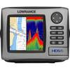
HDS-5 Nautic Insight Remanufactured No Ducer #055-0140-31
-
Olympic Coast National Marine Sanctuary Habitat Mapping: Survey Report and Classification of Side Scan Sonar Data from Surveys Hmpr-114-2004-02 and Hmpr-116-2005-01 [Book]
-
Waterproof Chart Kit - South Shore Long Island #WPB0340-02
-
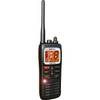
DE6141 Floating Marine Handheld vhfradio
-
Circle Cable Clips with Steel Nail, 40mm, 50pcs/Pack
-
10ft 28AWG DVI-A to SVGA (HD15) Cable - Black
-
6ft DB-25(IEEE-1284) Male to Mini/Micro Centronic 36(hpcn36) Male Cable [IE]
-
7ft 24AWG Cat6 550mhz UTP Ethernet Bare Copper Network Cable - Gray
-
Parts Express Marine Grade Locking Cigarette Lighter Plug 12 VDC
-
Guest 729830-P Second Station Kit
-
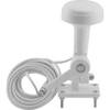
Tram 1655 8-ft Marine GPS Antenna