3208 l. Powell So
Model: 3208 Brand: Fish-n-Map
FISH-N-MAP UNDERWATER TOPOGRAPHY MAPSMade of waterproof, tear resistant plastic. Features include: underwater depth contours, fish locations, latitude and longitude for GPS, multiple freshwater lakes on one map, boat ramps, recreational facilities and much more.
Product Specification
-
Universal Product Identifiers
Part Numbers: 250129, 3208GTIN: 00761428032089
Related Products
-
Max EN-M300 North Sea and Denmark-MAX
-
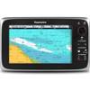
C95 9" Multifunction Display w/ US Coastal Charts
-
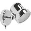
Marine ILIM4060 Auckland LED Reading Chart Marine Light
-
BlueChart g2 Vision - Lake Michigan - Maps
-
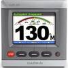
NAVPILOT 711 High-Performance, Universal Autopilot Package
-
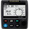
GHP10V Autopilot
-
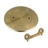
Screw in Deck Plates 5" Plate, Bronze
-
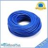
100ft 24AWG Cat6a 500mhz Stp Ethernet Bare Copper Network Cable - Blue
-
6ft Premium Optical Toslink Cable w/ Metal Fancy Connector
-
25ft 24AWG CL2 Standard HDMI Cable - White
-
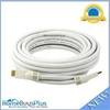
202234 50ft S-Video & 50ft RCA Audio Cable - Molded
-
700 Series 798ci SI Combo NVB - Marine Chartplotter - 5" color - 640 x 640