010-C0751-10 Bluechart G2 HAF451SNamibia to Knysna Sa Data
Model: 010-C0751-10 Brand: Garmin
Coverage of the southwestern coast of Africa from Cape Ponta-Grossa in Angola through Knysa, S. Including detailed coverage of Walvis Bay, Nam., as well as Port Nolloth, Hondelklipbaais, and Cape Town, S. Detailed coverage also includes the island of St. Helena, the Tristan da Cunha Group, and Gough Island. See your surroundings more clearly with BlueChart g2 data. With BlueChart g2, you'll get detailed marine cartography that provides convenient viewing of nautical content. BlueChart g2 allows you to see your vessel's precise, on-chart position in relation to naviads, coastal features, anchorages, obstructions, waterways, restricted areas and more. You will also have access to detailed mapping capabilities that include Safety Shading , Fishing Charts , smooth data transition between zoom levels, harmonious transition across chart borders, and reduction of chart discontinuities. « less
Product Specification
-
Universal Product Identifiers
Part Numbers: 010-C0751-10, 10804623, 35583GTIN: 00753759089719
Related Products
-
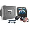
p70R & X-10 Corepack & Type 1 Pumpset Autopilot Package for Hydraulic Steered Powerboats T70079 c44130
-
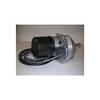
Dashboard Autopilot Drives for Cable Steering 24V 29010004
-
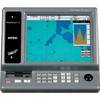
TRAWLPLOT 12 SD Color Chartplotter w/WAAS Receiver
-
010-00738-00 - Radar Pedestal, 6KW XHD
-
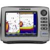
HDS-8 Insight USA Mltfnc 83/200 Fishfinder/Chartplotter 34252
-
NA-C401 Furuno FP Format - St. Lucie Inlet - LK Pontchart
-
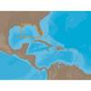
30131 Max - Central America and The Caribbean - C-Card
-
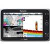
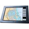
e165 15.4 Display Multifunction Coastal Chart #E70025-US
-
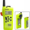
2828 SR203 GMDSS Survival Radio w/Replacable Lithium B
-
GB40 19 Inch Glass Bridge Navigation System (Requires GPS Antenna)
-
15ft 24AWG CL2 High Speed HDMI Cable w/ Net Jacket - White
-
E55051 - SeaTalk hs Network Cable, 10M