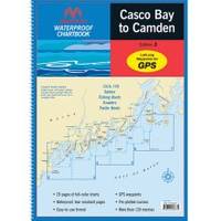
Waterproof Chart Book - Casco Bay to Camden 35266
Model: 35266 Brand: Maptech
Waterproof Charts w/ Companion CD WPB0220 220: Casco Bay to Camden Detailed coverage from Portland and Casco Bay to Muscongus Bay, Rockland, and Camden. Includes 29 chart pages, GPS waypoints, Lat. /Long. grids, courses, ramps, and 130 facilities. 12" x 17", scales 1:430,000 to 1:11,400 (predominant scale is 1:45,500). Product Overview These easy-to-use, compact chart books are ideal for Day-Sailors, Fishing Boats, and Trailer Boats. GPS Ready New features make Waterproof Chartbooks easy to use with your GPS. Most charts include one-minute lat./long. grids to make vessel positioning a breeze, and major navigation aids are identified with named GPS waypoints. Small and Large-Scale Charts Waterproof Chartbooks include small-scale, wide area charts as well as large-scale, detailed charts of harbors and approaches. The Chart Page Index (on the front cover) and "Go-To" page numbers make it simple to quickly find the chart you want. Pre-Plotted Courses Maptech's navigation editors add magnetic courses between major navigation aids with distances in nautical miles. Chartbooks are also designed to help you do the calculations yourself. Each page includes a Compass Rose with annual increase in variation and complete scale information. Waterproof and Tear-Resistant Waterproof Chartbooks have a durable plastic binding and are printed on high-quality, waterproof, tear-resistant paper. Chart images are crisp and easy-to-read. They can handle just about any conditions you'll find on the water - yes, that includes a spilled drink or two! "Paper and Digital Charts Together!" - A Maptech Exclusive It's all here...digital charts and the software tools to use them. And the great thing is the digital charts are the same identical charts with GPS waypoints and course lines - just like in the Chartbooks. Click to Create Routes Chartbook Companion CDs include "Offshore Navigator Lite" navigation software. Click your mouse to put a waypoint on a chart. Click again, and you're creating a route. It's that easy. Distances, bearings and GPS positions are calculated and displayed instantly « less
Product Specification
-
Universal Product Identifiers
Part Number: 35266
Related Products
-
AP2404VRF Autopilot AP24,AC42,RC42,RPU160
-
HDS-8 Base Mltfnc Fishfinder/Chartplotter w/ 83/200 K 34255
-
T70047 E97 Multifunction Display w/Sonar - US Inland Charts
-
Radar 5208 Package with GMR18 4KW Radome
-
NA-C101 C-Card Format - Superior, Huron, No Chan Grgn
-
Max AN-M203 W51 Yellow Sea to Malaya-MAX
-
KCA RC107MR Marine CD receiver remote control unit
-
Video cable - Male 19 pin HDMI Type A to M 18 pin digital DVI (Single-Link)
-
6ft 32AWG Mini DisplayPort Cable - White
-
N-Type-Cp/Cs-01 Connector for Rg-58Au Cable
-
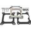
Marine Power 441220 Adapter Plate 262 Holley
-
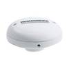
AS GR16 - Marine GPS receiver