The Sea Chart: An Historical Survey Based on the Collections in the National Maritime Museum [Book]
Product Specification
-
Authors: Derek Howse, Michael W. B. SandersonPages: 144Format: bookPublication Date: 1973
-
Universal Product Identifiers
ISBN: 0070306028GTIN: 09780070306028
Related Products
-
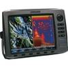
HDS 10 Base Sonar / Chartplotter US 83/200kHz 140-00
-
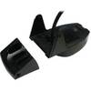
492/50/200ST-ES Ducer F/ EC5F EC7F ES502
-
010-C0849-10 Bluechart G2 HEU505SBaltic Sea East Coast Data
-
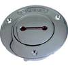
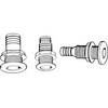
0528007PLB 1.25 Unmarked Deck Fill Bronze
-
LED Navigation Lights, Masthead Tricolor w/ Anchor 65 ft
-
10ft 24AWG CL2 Flat High Speed HDMI Cable - Black
-
25ft 24AWG Cat6a 500mhz Stp Ethernet Bare Copper Network Cable - Blue
-
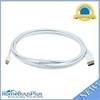
10ft 32AWG Mini DisplayPort to DisplayPort Cable - White
-
Patch cable - CAT 6 - RJ-45 - M - Unshielded twisted pair (UTP) 14 ft - Gray
-
Th-1202-B Thru Hull 1-1/8" White 1-1/4" Hull
-
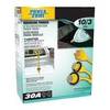
Power Zone ORMAD30Y Marine Y Adptr 30A Plg 30A CON
-
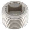
Marine Products Plug, Stainless Steel, 3/4 9-41205