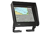
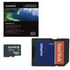
River ECDIS 1CSOENKI/ECDIS 270 1D
Model: SOENKI/ECDIS 270 Brand: Sea Sense
1CSOENKI/ECDIS 270 1D is a universal electronic chart system that allows ECDIS (Electronic Chart Display and Information System) equipment to be used as conventional for marine vessels carrying out international routes.
AAElectronic Chart Display and Information System 1CSOENKI/ECDIS 270 1D is intended for installation on marine vessels, river boats and vessels of mixed type (river-sea). The advantage of the equipment is functionality designed for sea and river vessels with a rapid transition from the sea operating mode to the river, and vice versa.AThe 1CSOENKI/ECDIS 270 1D system can be installed on marine vessels and connected to the equipment in both single execution and as a part of the integrated navigation system. The ability to duplicate the chart and navigation information replaces paper charts in the vessel operation, which is regulated by the International SOLAS Convention. The equipment supports integration of all marine vessel navigation information and operational decisions concerning marine navigation safety issues.AThe search in the menu can be made in both English and Russian languages.AFunctionalityAAThe electronic chart system 1CSOENKI/ECDIS 270 1D includes:AA Electronic Chart Display and Information System;A Route planner;A Route monitoring and tracking of objects in the vicinity of the marine vessel;A Alarm system;A Correction and updating of electronic map charts and chart collection;A Navigation equipment integration system;A Navigation sensor control system;A Backup and recovery of navigation information record.AA 1CSOENKI/ECDIS 270 1D equipment provides a range of functions specifically for operation on inland waterways (IWW):AA Switching navigation mode from sea going (speed in knots, range in miles) to river going conditions (speed in km/h, range in km) and vice versa in the real navigation mode;A Recording of track data; built-in audio module enables prompt recording of the waypoint information with playback at a time convenient for navigator;A Ability to quickly chart all available river markers on electronic charts in manual electronic correction mode;A Calculation of the point of approach to the vessel on the curved river sections according to AIS information from oncoming or overtaken (overtaking) vessel;A Towing of objects with the addition of the object contours on the screen over bow, aft, starboard or port side;A Logging on the main panel the value of kilometre performance and of the distance from it to current location of the vessel.Related Products
-
VEU458S, Goteborg to Fyn, BlueChart g2 VISION, microSD/SD
-
VUS513L-Jacksonville - Bahamas, BlueChart g2 Vision, SD Card
-
VEU492S, Kristinestad to Hanko, BlueChart g2 VISION, microSD/SD
-
Hotmaps Premium CF Canada
-
HEU490S, Greece West Coast and Athens, BlueChart g2, Garmin Datacard
-
HXPC416, New Zealand N., BlueChart g2, microSD/SD
-
HEU712L, Sweden East, BlueChart g2, Garmin Datacard
-
HXAF452, Knysna, SA to Beira, MZ, BlueChart g2, microSD/SD
-
HXEU454, Barcelona and Valencia, BlueChart g2, microSD/SD
-
VUS033R-Bristol Bay-Kotzebue, U.S., Alaska, BlueChart g2 Vision, SD Card
-
HAW003R, Indian Subcontinent, BlueChart g2, Garmin Datacard
-
HEU457S, Bretagne, BlueChart g2, Garmin Datacard
