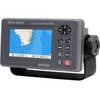
Radar 4210 Package with GMR24HD 4KW Radome & GSD22 Sounder
Model: GMR24HD Brand: Garmin
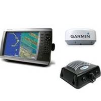
The package includes Garmin GPS Chartplotter Garmin GPS Antenna Garmin Radome Garmin Sounder GSD22 Garmin Power, GPS, and Radar cables Manuals This mid-sized 4000 series chartplotter fills the gap between the smaller GPSMAP 4208 and the wider GPSMAP 4212. Like its counterparts, the 4210 combines the power of networking with brilliant color and slim-line design. This chartplotter has preloaded BlueChart g2 maps of the U.S. coast and displays them on a 10.4" SVGA display with crisp, video-quality resolution. By connecting to the Garmin Marine Network, you can add sonar, radar and weather. For even more enhanced features, you can add the optional BlueChart g2 Vision card. View Detailed Graphics and Video The 4210 features highly detailed BlueChart g2 marine cartography of the coastal United States, including Alaska, Hawaii and the Bahamas. This data provides detailed coastlines, shaded depth contours, navaids, port plans, wrecks, restricted areas and tide and current information. For other areas, the 4210 has a worldwide basemap with high-quality satellite images in place of more traditional maps. With the SD card slot, you can add additional maps. Add Extras with BlueChart g2 Vision With optional BlueChart g2 Vision SD cards, you can add a whole new dimension of exceptional features to your chartplotter. Choose to view 3D map information at "mariner's eye view" above the waterline or "fish eye view" below the water. High-resolution satellite images and aerial photographs help you orient yourself in unfamiliar areas. Auto Guidance technology searches through all relevant charts to create a route you can actually follow one that avoids obstacles, shallow water, buoys and other obstructions. Connect to the Garmin Marine Network The 4210 connects easily to the high-speed Garmin Marine Network, so you can interface with additional MFDs and add remote sensors. Once connected, you can share information between the 4210 and other chartplotters on your boat. You can also add high-powered radar, sonar and XM satellite weather and radio to your system. "Turn right in 500 ft."): no Remote control: yes (optional) Headphone jack/audio line-out: no Audio/video input/output: yes Portable: no Automotive/motorcycle-friendly: no Additional: Interface Inputs/Outputs: 3 built-in network ports, 4 NMEA input (supports NMEA 2000), 2 NMEA output, 2 video inputs for onboard cameras, 1 SVGA PC monitor What's in the Box: GPSMAP 4210 GPS 17x NMEA 2000 Bail mount and knobs Protective front cover Top and bottom snap covers Video cable assembly Power cable assembly NMEA 0183 cable NMEA 2000 drop cable NMEA 2000 10 m backbone cable NMEA 2000 power cable NMEA 2000 T-connector & terminator kit Flush mount hardware Flush mount gasket Marine grommet kit Owners manual on disk Quick reference guide Installation instructions GPSMAP 4210 Part Number: 010-00690-01 Manuals Flush Mount Template (Multilingual), Rev. D, Jan, 2008 | Download NMEA 2000 Network Fundamentals, Rev. A, Jan, 2008 | Download Owner's Manual, Rev. A, Jan, 2008 | Download Quick Reference Guide, Rev. B, Jan, 2008 | Download EL Quick Reference Guide, Rev. B, Jan, 2008 | Download RU Quick Reference Guide, Rev. B, Jan, 2008 | Download Some downloads may require Adobe Acrobat Reader. Download a free copy here . « less
Product Specification
-
Universal Product Identifiers
Part Number: gmrpack14
Related Products
-
GPS 95CPI GPS Plotter with Internal Antenna c31313
-
Package(c127 with aus, NZ, S. America, Asia Chart, 4KW 18 Inch Digital Radome & Radar Cable)
-
Marine Chart A
-
FBRS 2774 Battery Service Includes 1096 Batt Parts Labor
-
The Nautical Chart: A Novel of Adventure [Book]
-
Elements of Navigation, Chart, Lead, & Log Deviation & Compass Compensation, Piloting, Dead Reckoning, Nautical Tables [Book]
-
18inch SATA Data and Power Combo Cable - Silver
-
Guest 297 Second Station Kit for 296-5 c10821
-
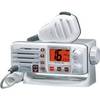
Eclipse DSC GX1000 - VHF Marine Radio
-
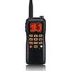
HX760S 6 Watt with Blue Tooth Headset
-
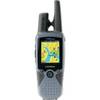
RINO 520HCx - Hiking GPS receiver / two-way radio - Color - 176 x 220
-
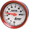
Livorsi Gpss100K1Cfpssrr 3 3/8 GPS 100 MPH Kit Black CF