NaM024 CCard Format u.s.west Coast and Hawaii
Model: NaM024 Brand: C-Map
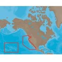
NA-M024 > USA West Coast and HawaiiCoverage of the Pacific Coast of the United States, including all of the coasts of California, Oregon and Washington. Coverage of Baja California and Mexico down to Puerto Vallarta. Detail of the Columbia River, Sacramento River, Willamette River. Snake River and San Joaquin Rivers are also included. Full coverage of Puget Sound and the San Juan Islands up to Point Roberts is also included. Additional coverage of the Hawaiian Islands out to Midway and Johnston Atoll is also included. « less
Product Specification
-
Universal Product Identifiers
Part Numbers: 30132, CMANAM024CCARD, NA-M024, NA-M024-C, NA-M024C-CARDGTIN: 000000165838, 00686074002753
Related Products
-
Transom Mnt Depth Triducer (P66) E26028
-
Package(C140W, 4KW 24 Inch Digital Radome & Radar Cable)
-
010-C0772-20 Bluechart G2 HXEU014RItaly Adriatic Sea Microsd/sd
-
NAVPILOT 711 High-Performance, Universal Autopilot Package
-
FBRS 2775 Battery Serive Includes 1096 Batt Parts Labor
-
166-5141 Boat Hook Replacement Tip Tough Strong Non
-
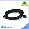
4959 12ft 28AWG Standard HDMI Cable w/Ferrite cores - Black
-
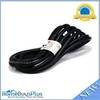
15ft 16AWG Power Cord Cable w/ 3 Conductor PC Power Connector Socket (C13/5-15P) - Black
-
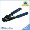
High Quality 8P8C RJ-45 Network Cable Crimper [HT-210C]
-
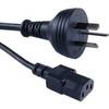
Cable Showcase Austrailian Power Cord UL/CSA, 6 ft
-
10ft USB A to Mini-B 5pin 28/28AWG Cable
-
GP32 4.5 Inch Monochrome LCD WAAS/GPS Receiver & Navigator